Mount Brinchang
Cameron Highlands Index
Mount Brinchang
After Mount Irau (elevation : 2110 m), Mount Brinchang (elevation : 2031 m) is the second highest mountain in Cameron Highlands. It is one of the most popular treks in the area as it is easily accessible by what is considered the highest road in Malaysia.
Before we go on, please jot down the numbers that are listed below. If you do see any suspicious behaviour when out hiking, encounter things like traps and snares, or even see protected animals or their parts that are sold as either collectibles, pets, or for (so-called) medicine, then please do not hesitate to contact the wildlife crime hotline. Be sure to try and document it as best you can with photos or video without putting yourself in danger, and take note of the details: descriptions of those who are involved, as well as when and where it took place."The Wildlife Crime Hotline, managed by the Malaysian Conservation Alliance for Tigers (MYCAT), provides YOU an avenue to report offences involving endangered wildlife in Malaysia. We protect the identity of all informants, only key info of the reports are forwarded to the authorities."
Emergency Numbers
Wildlife Crime Hotline 019-356 4194 Wildlife Department 1800 885 151 Cameron Highlands Forestry Department 09–3551 060 Cameron Highlands Hospital 05-4911 966 Cameron Highlands Bomba 09-4911 003 Tanah Rata Police Station 05-4915 443 Ringlet Police Station 05-4956 222 Kg. Raja Police Station 05-4981 222 JKR Cameron Highlands 05-4911 105Difficulty Rating : 2.6 / 10.0
(Class 3 - Straightforward)

Road to the Trail Head
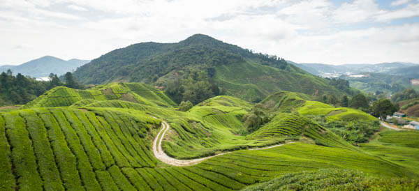
The five-kilometre-long, narrow and windy road begins at a left turning as you make your way north from Brinchang and can be found by following the signs that show the way to the Sungai Palas Boh Tea Plantation.The map below shows the road that leads to the start of the trail for the trek up to Mount Irau. Following the road a little further (approximately one kilometre) will bring you to the peak of Mount Brinchang. Be aware though that about two kilometres into the road you will come across a junction that leads to the Sungai Palas Boh Tea Plantation itself. Turn left at this point.

The peak of Mount Brinchang is dominated by a station dedicated to a tall telecommunications tower, which also functions as a landmark for those who scale the other mountains on the Titiwangsa Range. There is also a watchtower to the side of the road that can be accessed for some interesting views of the surrounding area, and this was where we ended the trek.
We began the trek much closer to the town of Brinchang itself. On the main road that hosts the weekend night-market, there is a left turning (when making your way northwards) that lies just opposite the Brinchang Police Station. This road (which is next to army quarters) is narrow and filled with potholes but there is limited space where the road meets a fork (just before trail 1 begins) where most people park their vehicles. The trek begins at the fork that I mentioned that has a signboard that shows the direction of Trail 1. The initial part of the trail leads you up a paved road where you will come across a water catchment center that lies just before the start of the section of the trail that leads into the forest. This section can be easily seen as there is large sign showing the way.
Getting There

 The trek itself was not physically strenuous and was also relatively short. The sheer size of our group brought the pace of the trek down considerably (1.3 km/h) but even despite this, we were able to reach the peak of Mount Brinchang in approximately 2 hours, covering a total distance of 2.7 km. We could easily have cut the time in half going at our regular trekking pace, which would also be the case for those who are experienced hikers and are fairly fit. The trail itself was a gradual ascent all the way to the peak with a total elevation gain of 433 metres.


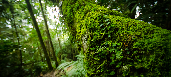
The slow and relaxed pace combined with the gradual incline and the low difficulty of the trail enabled us to take our time and appreciate the lush plants and gorgeous moss that abounded the region at this elevation. The mossy epiphytic vegetation of the cloud forest that we saw along the trail served as a precursor to the beautiful mossy forests of Mount Irau that we were to encounter the following day. The combination of the low temperatures, the soft fuzzy textures of the surrounding plants, and the mist and breeze that would sweep in occasionally made the whole trek very scenic and pleasant and at certain points almost surreal.
There were a few viewpoints that we encountered along the way where the foliage opened up revealing the mountain vistas that lay to the west. After stopping for a while to take in the surrounding landscapes, we found that the trail came to an end about 15-20 minutes after that point. A fence materialized that surrounded the compound that contained the telecommunications tower within. Following a small path to the left that circumnavigated the compound lead us to the road and the watchtower that I had previously mentioned. From this point we had the choice to either make our way down the long windy road (which would have been far more time consuming) or to just descend back down the trail that we had just come up.
Route Playback
Suunto Movescount Stats
Mountains of Malaysia
Malaysia Overview


