The Ngozumpa Glacier

I slept for ages that night, going to sleep around 18:00 just after dinner and waking up around 06:00 the next morning. I am accustomed to getting about six hours of sleep every night, so such a long duration is very unusual and was an indication that the
Cho La pass must have taken a toll on me. The 'Khumbu cough' had also finally caught up to me, leaving my throat not just dry but also a little phlegmy.
I decided to have macaroni and cheese (
NP450) once again for breakfast and had three cups of coffee (
NPR100x3) in an attempt to shake off the grogginess (although the coffee probably did not help too much with the cough, nor the cheese with the phlegm!).
The walk up to the Ngozumpa glacier

was a slow one, and my body felt a little indolent, almost as if it were saying that the last two weeks of hiking were enough. My backpack seemed to be heavier than ever before, but all I could do was keep going north and up the moraine of the glacier. I bumped into a Canadian called Florian then, who had apparently been separated from his mother and was walking around looking for her. He told me that they had plans to stay at the Cho Ryu lodge in Gokyo, as the sister of the owner of the previous lodge, Tashi, had (undoubtedly) recommended the place.
 Looking southward along the glacier rim; twisted bands in the rocks
The start of the crossing was easy to spot as there was a little flag fluttering on the edge that indicated the location of the trail head

. This surprised me however, as the trail across the glacier is constantly changing due its shifting terrain over time. As I rounded the moraine, the entirety of the massive glacier slowly came into view. Before me lay the Ngozumpa glacier--the longest glacier in Nepal. Its huge mass (with an area of 61 km2) descended south for 18 kilometres from the upper reaches of the valley: the mountains of Gyachung Kang (
elevation : 7922 m) and Cho Oyu (
elevation : 8188 m).
The glacier did not look like a body of ice at all, as its surface consisted of a dark layer of rock and gravel. This was because debris-covered glaciers tend to pick up rocks as they make their way slowly down the slopes. This increase in mass also means an increase in thickness towards the terminus. When I finally stepped on the glacier, the surroundings seemed almost
otherworldly. Between the mazes of rocks and gigantic boulders, there were huge ice cliffs that descended precipitously down to the ice lakes below. I found navigation to be a little bit of a challenge as the trails sometimes lead to dead ends or to the edges of drop-offs. The strange sounds were also a little unnerving, as groans and pops echoed around me as the mass shifted and caused rocks to move and fall.
 A Ngozumpa glacier ice cliff...
Rising temperatures have caused most glaciers around the world to shrink and to retreat. The melting ice causes a formation of 'perched lakes' that lie on the surface of the glacier, and much larger 'spillway lakes' further down the glacier as the
ice melts from underneath and the glacier channels the melt-water downwards. Some measurements suggest that the Ngozumpa glacier could be declining at a rate of almost two metres every year!
 ...and one of the many perched lakes
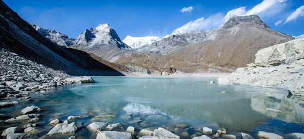
It took just over an hour to cross the glacier despite my slow pace, a pace that was compounded by my (glacier dust-agitated) Khumbu cough. Soon after, I was greeted by the glorious sight of the lake of Gokyo Cho (aka 'Dudh Pokhari') as I rounded the moraine on the west side of the glacier. The lake is a part of the world's highest freshwater lake system, and gets its water from water seepage from the Ngozumpa glacier right beside it, as well as streams that run down from the
Renjo La pass. The water of the lake is also very clear due to the low algal production, which is a direct result of the low nutrient content of oligotrophic lakes like this. The low algal production also happens to make them good sources of drinking water!
I sat on the side of the moraine transfixed, watching the sunlight twinkle off the vibrant turquoise body of water. After what seemed like an eternity, I finally got my feet to move once again and began my descent down to the village of Gokyo (Nepali : गोक्यो)

(
elevation : 4750 m).
Suunto Movescount Stats

 Download GPX file here (right click and save link as)


