
Mount Jasar
Cameron Highlands Index
Mount Jasar
Mount Jasar can be reached with a short trek via trail 6 from the Cameron Bharat Tea Plantation as well as from trail 10 which begins just behind the Oly Appartments and at the end of Tan's Camellia Garden. Tan's Camellia Garden is private property however so if you find the gates to be closed, you can just head up the slope to the right of the compound before you reach the gates which will also end up leading to trail 10.
Before we go on, please jot down the numbers that are listed below. If you do see any suspicious behaviour when out hiking, encounter things like traps and snares, or even see protected animals or their parts that are sold as either collectibles, pets, or for (so-called) medicine, then please do not hesitate to contact the wildlife crime hotline. Be sure to try and document it as best you can with photos or video without putting yourself in danger, and take note of the details: descriptions of those who are involved, as well as when and where it took place."The Wildlife Crime Hotline, managed by the Malaysian Conservation Alliance for Tigers (MYCAT), provides YOU an avenue to report offences involving endangered wildlife in Malaysia. We protect the identity of all informants, only key info of the reports are forwarded to the authorities."
Emergency Numbers
Wildlife Crime Hotline 019-356 4194 Wildlife Department 1800 885 151 Cameron Highlands Forestry Department 09–3551 060 Cameron Highlands Hospital 05-4911 966 Cameron Highlands Bomba 09-4911 003 Tanah Rata Police Station 05-4915 443 Ringlet Police Station 05-4956 222 Kg. Raja Police Station 05-4981 222 JKR Cameron Highlands 05-4911 105Difficulty Rating : 2.2 / 10.0
(Class 2 - Very Straightforward)

Getting There
Trail 10 is a gentle route that goes on for two kilometres before reaching the peak on Mount Jasar. Soon into the walk you will come across a sign that marks the junction for route 11 that goes on to Mount Perdah that states a distance of 3.5 km. Instead of turning right, just keep on walking straight ahead. The trail progresses with a very gradual slope for the first kilometre but after this the incline increases and is sustained for another 400 metres or so.

Insect Traps
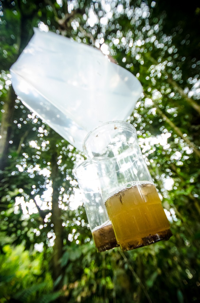 We also came upon what we discovered later on to be insect traps that had been set up by insect smugglers. The traps were intended to catch highly desirable insects like tarantulas (Family: Theraphosidae), trapdoor spiders (Family : Ctenizidae), and some beetle species, many of which are protected under the National Forestry Act of 1984. The traps were constructed with a vertical plane of almost transparent plastic that was connected to a funnel that lead to cups at the bottom. The cups themselves were filled with a sweet smelling liquid that had likely been put there to attract the insects. I initially thought that the traps were devices that were used to collect the secretion of certain vines and plants and that the liquid that had collected in the cups was the secretion that was diluted in rain water. As such, we ended up leaving the devices as we had found them before proceeding along the trail.
The incline ended shortly after at another junction of sorts with the path continuing up through some fields of grass on the right. There was a view on the right of the trail where the town of Tanah Rata could be seen down below. The development that could be seen was somewhat depressing as we realized that with the current rates of development, the pristine conditions of the forests that surrounded us would not last for much longer. This realization was also made more evident as we made our way along the trail and saw a large electrical pylon (transmission tower) that dominated the hill to the left. The path veered left just after and brought us directly underneath the tower with large swaths of the land covered by green plastic sheets to prevent landslides from the erosion. The clear-cutting and deforestation that had been carried out here would only have increased the likelihood of landslides occurring since the so-called 'glue' that the tree roots provide had been destroyed. I only wished how more people would realize how the destructive nature of humankind tends to wreak havoc with nature, and destroys the habitats of other animals that call the forest their home.

360 Panorama
Route Playback
Suunto Movescount Stats


Mountains of Malaysia
Malaysia Overview


