Lepoh Waterfall
PROTECTED STATUS :
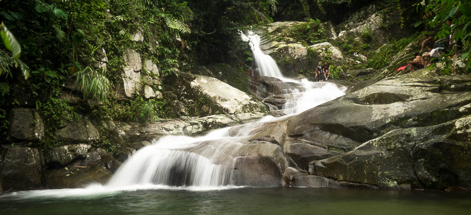
Lepoh Waterfall is a relatively small waterfall, but the cascades and the rock formation that it runs over make it a fairly attractive one. The waterfall is located in the forest of Ulu Langat, and lies just three kilometres to the west-south-west of the summit of
Nuang.
Before we proceed any further however, I have to take a moment to make a disclaimer and to urge you to use common sense and caution when doing anything in the vicinity of the waterfall, and especially so when preceded by a bout of rain. Please also jot down the numbers that are listed below. If you do see any suspicious behaviour when out hiking, encounter things like traps and snares, or even see protected animals or their parts that are sold as either collectibles, pets, or for (so-called) medicine, then please do not hesitate to contact the wildlife crime hotline. Be sure to try and document it as best you can with photos or video without putting yourself in danger, and take note of the details: descriptions of those who are involved, as well as when and where it took place.
"The Wildlife Crime Hotline, managed by the Malaysian Conservation Alliance for Tigers (MYCAT), provides YOU an avenue to report offences involving endangered wildlife in Malaysia. We protect the identity of all informants, only key info of the reports are forwarded to the authorities."
Wildlife Crime Hotline019 356 4194
Emergency Numbers
Wildlife Crime Hotline 019-356 4194
Wildlife Department 1800 885 151
Selangor Forestry Department 03-9075 2885
Batu 18 Police Station 03-9021 1557
Ampang Bomba 03-4292 4444
Ampang Hospital 03-4289 6000
Medical Emergency Coordination Centre (MECC Ampang Hospital) 03-4289 6565
Asli Adventure Camp Leader 012-233 9587
*Click here to learn more about the difficulty rating.

Getting There
To get to Lepoh Waterfall from Kuala Lumpur, you will need to make your way north-east towards Kuala Pangsoon and Hutan Lipur Gunung Nuang but turn off at a left turning (3.209648, 101.864026) that heads northward towards the Asli Adventure Camp before reaching Kampung Kuala Pangsoon (the junction has signboards that point to 'Sungai Lopo'). The trailhead lies at the end of the narrow road with the gate of Asli Adventure Camp on your left.
Directions to Asli Adventure Camp junction (at GPS location 3.222286, 101.863980)...
...and the trail head.
The hike itself is fairly easy, and it follows the north cardinal axis almost the entire way, taking approximately two hours each way to complete. Once
Asli Adventure Camp is passed on the left, the trail to the Lepoh Waterfall begins straight ahead. You will have to cross the river almost immediately after the trail swerves right, and hop from stone to stone to keep your shoes dry, just before arriving at the first junction. Taking the right branch here brings you to the first rickety wooden bridge that leads to a wide trail, and then on to another bridge that crosses a fast-flowing river just after. Stepping on the wooden sections directly above the stronger beams will minimise the chances of the wood breaking off beneath your feet.
You will reach a cemented incline (that can get quite slippery after rainfall) about 200 metres into the trail that widens out for a bit before the vegetation closes back in once again. Two hundred metres after that lies another set of crossroads and taking the wider left turning keeps you on the bamboo-lined
(Tribe : Bambuseae) trail to Lepoh Waterfall.
 The second bridge crossing.
Approximately 1.4 kilometres in, the trail will abruptly widen out into a grassy clearing filled with rubber trees
(Hevea brasiliensis), before passing a wooden hut shortly after. The trail leads to a fork two kilometres in where you should be able to hear the rustling of the river down to your left, and it doesn't seem to make a difference which one of the two branches of the fork you take as they seem to converge once again after a while. A few hundred metres later, approximately an hour into the hike, a huge pipe will suddenly appear right in front of you, with the distant end tapering off and disappearing into the dense vegetation. If you are here early enough in the morning, you may even hear the loud hooting calls of bands of siamang gibbons
(Symphalangus syndactylus) above in the canopy. These arboreal primates are frugivorous and are the largest of the lesser apes, occasionally reaching almost a metre in height.
 The pipes of Lepoh Waterfall
The trail begins to climb around 2.7 kilometres in, approximately 15 to 20 minutes after you first encounter the pipes. Large roots of trees criss-cross the trail here, leaving natural steps that assist hikers with their ascent. After about 400 metres of climbing, the trail tapers out onto a ridge that follows the contour lines for a few hundred metres, with the roar of the river clearly audible down to the left. An abandoned structure will appear two hundred metres before the waterfall, a sign that the waterfall lies just around the corner!

Fortunately, there is a little trail on the right side of the riverbanks that leads up to the main waterfall and the natural slide, as it is very tricky to ascend the waterfall directly up the rocks from the main pool. Even though the angle of the slide is fairly tame, accidents can happen to anyone at anytime, so please proceed carefully and at your own risk. There is apparently another trail on the left side of the river that leads up to the top tier of the waterfall.


Suunto Movescount Stats

 Download GPX file here (right click and save link as)