


Tabur West
Tabur West - Tabur East Tabur Far East - Tabur Extreme
Tabur West
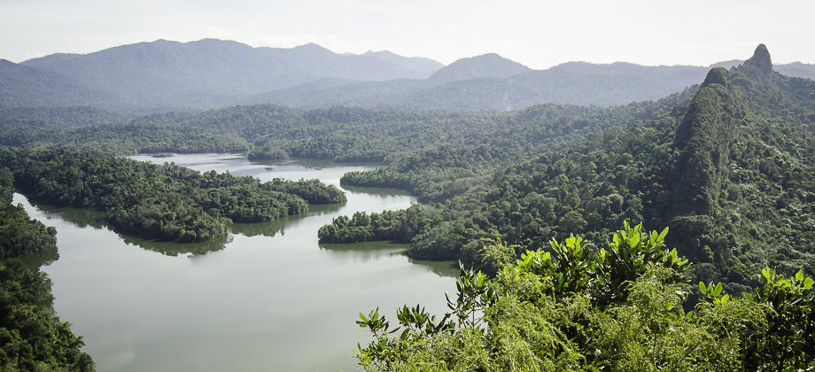
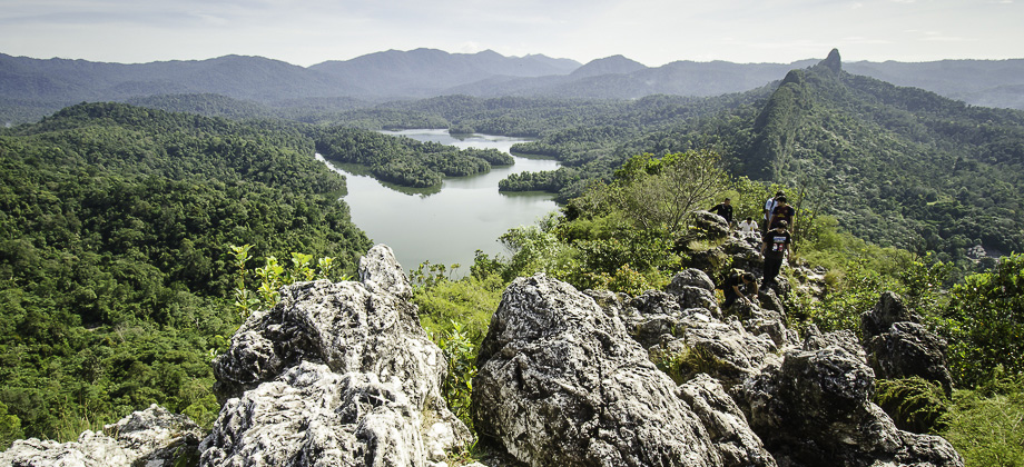
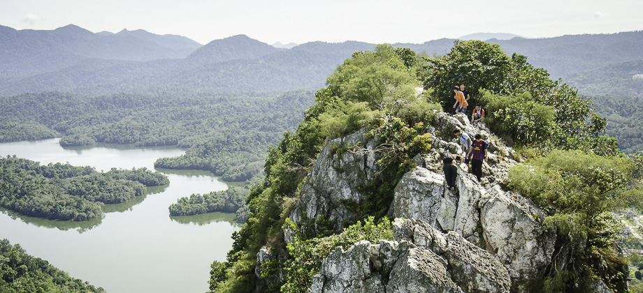
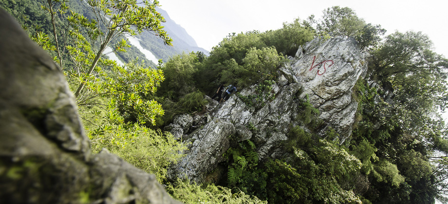
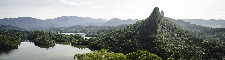
We finally set off for the Tabur West hike after the trip having been postponed from the weekend before. Bukit Tabur is a quartz ridge, that is also known as 'The Dragon Backbone', located at Taman Melawati in Kuala Lumpur. It is apparently the longest quartz outcrop in the world that boasts a wide range of flora and fauna, including Dusky Langurs (Trachypithecus obscurus). I didn't actually see any langurs during the hike itself but definitely heard all the commotion that they were making! Tabur has several peaks that can be traversed but the trail for the more popular west route starts on the left side of the road (coming from KL) near the Klang Gates entrance.
Before we go on, please jot down the numbers that are listed below. If you do see any suspicious behaviour when out hiking, encounter things like traps and snares, or even see protected animals or their parts that are sold as either collectibles, pets, or for (so-called) medicine, then please do not hesitate to contact the wildlife crime hotline. Be sure to try and document it as best you can with photos or video without putting yourself in danger, and take note of the details: descriptions of those who are involved, as well as when and where it took place."The Wildlife Crime Hotline, managed by the Malaysian Conservation Alliance for Tigers (MYCAT), provides YOU an avenue to report offences involving endangered wildlife in Malaysia. We protect the identity of all informants, only key info of the reports are forwarded to the authorities."
Emergency Numbers
Wildlife Crime Hotline 019-356 4194 Wildlife Department 1800 885 151 Hulu Selangor Forestry Department 03-6091 613 Taman Melawati Police Station 03-4108 1222 Wangsa Maju Police Station 03-9289 9110Difficulty Rating : 3.0 / 10.0
(Class 3 - Straightforward)
*Click here to learn more about the difficulty rating.

Tabur Elevation Profile
Notice: Tabur Trails Temporarily Closed
Recently Bukit Tabur has been plagued with a number of unfortunate accidents which have prompted the authorities to temporarily close all the trails. The notice that was issued today (when translated from Malay) Read more
Getting There
The windy road up to the start of the trek would be hard to find if one does not know exactly how to get there. We didn't have any problems finding the place as Andy had done some reconnoitering prior to the trip. The proximity of the route was also made fairly obvious by the presence of the numerous cars found parked at the side of the narrow road, although this made parking a little tedious. We finally found a parking spot down the road and once the car was tucked into the side of the road safe & sound from oncoming traffic, we made our way back up the road to the start of the route  (coordinates are '3.233921, 101.749046').
Location of the start of the trail
Tabur Elevation Profile

Notice: Tabur Trails Temporarily Closed
Getting There
The windy road up to the start of the trek would be hard to find if one does not know exactly how to get there. We didn't have any problems finding the place as Andy had done some reconnoitering prior to the trip. The proximity of the route was also made fairly obvious by the presence of the numerous cars found parked at the side of the narrow road, although this made parking a little tedious. We finally found a parking spot down the road and once the car was tucked into the side of the road safe & sound from oncoming traffic, we made our way back up the road to the start of the route ![]() (coordinates are '3.233921, 101.749046').
(coordinates are '3.233921, 101.749046').
After putting on the heart rate monitor and starting the exercise mode on the Suunto Ambit, we made our way up the route. The climb itself started off steep right from the start and stayed that way for the next 15 minutes or so (this is evident from the graph of the elevation gain plotted from the Ambit data that was posted on my Movescount Page). The route started to level off with intermittent steep sections every now and then.
The trail was clearly widely used which made it very obvious, with almost no chance of accidentally diverting from the route. The slim chance was made even slimmer as I had plotted the route and uploaded it onto the Ambit several days prior. The most obvious advantage to having done this (on this occasion at least) was the ability to track our current position and our overall progress along the route itself. I was constantly reminding the group of this with occasional shouts of "We are about a third of the way to the peak!" and the sort.
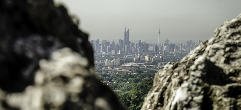
Soon after, we were greeted by some breathtaking views of the Klang Gate Dam that lies just to the north. Being interposed between the gorgeous greenery and some spectacular views of urban KL to the south made for quite a visual treat! To make things even better, every time we reached another so-called 'peak', we had only to turn back to be rewarded with views of the very prominent quartz ridge, or rather the 'backbone', from whence we came.
Next : Tabur West (Part 2)
Malaysia Overview
")


Hi,
I was wondering if I could share your post? Where is the link? I can’t find it thanks.
Hi Johnnie!
Sure you can! But which post are you referring to?
The one for this Bukit Tabur entry is:
http://ramonfadli.com/2012/12/29/bukit-tabur-hike/
The 360 pano is:
http://www.360cities.net/image/bukit-tabur#37.25,23.09,70.0
Hope this helps!
Ramon
Here is the 360 degree panorama that was taken during this trek :
http://www.360cities.net/image/bukit-tabur#37.25,23.09,70.0