
Mount Ulu Semangkok & Mount Gap
Mount Ulu Semangkok
Mount Ulu Semangkok is located in the Ulu Tranum Forest Reserve that lies in-between the states of Selangor and Pahang. A lot of people seem to mistake Mount Ulu Semangkok for Mount Semangkok which is a completely different mountain with a summit that lies at a much higher elevation and a trail that makes for a much tougher trek. The trail that we took leads to the summit of another mountain called Mount Gap, which lies at an elevation of 1183 metres, before continuing on to the summit of Mount Ulu Semangkok (elevation : 1394 m).
Before we go on, please jot down the numbers that are listed below. If you do see any suspicious behaviour when out hiking, encounter things like traps and snares, or even see protected animals or their parts that are sold as either collectibles, pets, or for (so-called) medicine, then please do not hesitate to contact the wildlife crime hotline. Be sure to try and document it as best you can with photos or video without putting yourself in danger, and take note of the details: descriptions of those who are involved, as well as when and where it took place."The Wildlife Crime Hotline, managed by the Malaysian Conservation Alliance for Tigers (MYCAT), provides YOU an avenue to report offences involving endangered wildlife in Malaysia. We protect the identity of all informants, only key info of the reports are forwarded to the authorities."
Emergency Numbers
Wildlife Crime Hotline 019-356 4194 Wildlife Department 1800 885 151 Hulu Selangor Forestry Department 03-6091 613 Fraser's Hill Police Station 09-362 2222 IPD Hotline Raub 09-355 4999 Fraser's Hill Health Clinic 09-362 2482 Klinik Desa Bukit Fraser 09-369 7919Difficulty Rating : 3.0 / 10.0
(Class 3 - Straightforward)
*Click here to learn more about the difficulty rating.

Getting There
The start of the trail lies at the side of the road just before the Gap, which is a base station where the road branches off to the windy 8-km-long road that leads up to Fraser's Hill. The trail entrance is somewhat hidden and very inconspicuous and will probably be hard to locate unless accompanied by someone who has done the trek before. The GPS coordinates for the start of the trail are 3.690908,101.749572 and it lies just opposite an old abandoned house just before the structure known as the 'GAP Resthouse'.
Location of the start of the trail
Getting There
The start of the trail lies at the side of the road just before the Gap, which is a base station where the road branches off to the windy 8-km-long road that leads up to Fraser's Hill. The trail entrance is somewhat hidden and very inconspicuous and will probably be hard to locate unless accompanied by someone who has done the trek before. The GPS coordinates for the start of the trail are 3.690908,101.749572 and it lies just opposite an old abandoned house just before the structure known as the 'GAP Resthouse'.
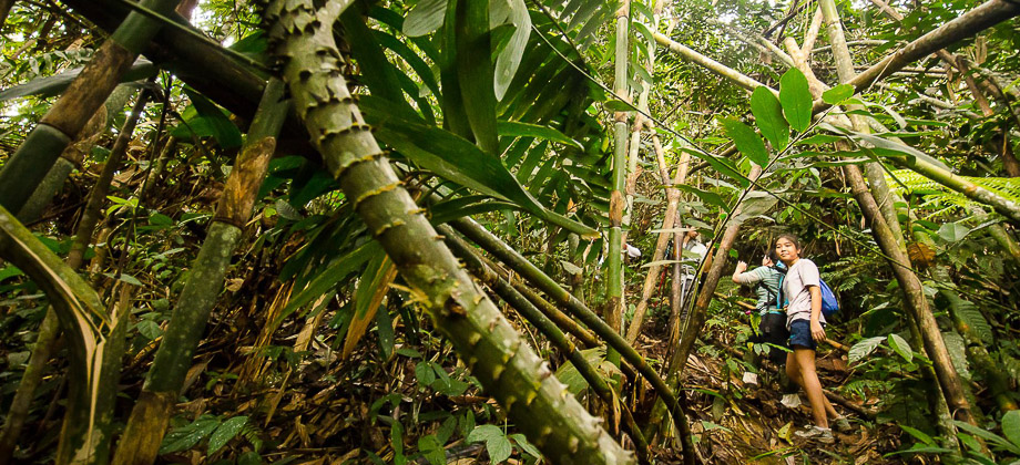
The group that had gathered was fairly large (consisting of 25 people) and was led by a veteran trekker called MK Rahman from the Facebook group Hiking & Camping Around Malaysia and with whom I had trekked with before. We set off at 09:13 just after taking a group photo and made very slow progress (almost to the point of constantly stopping and starting) due to the sheer size of the group combined with the narrowness of the trail. Some of the trekkers found the inclination and the terrain to be difficult as the mud made the path that was already criss-crossed with bamboo shoots (Tribe : Bambuseae) somewhat slippery. My boots had very thick soles with deep treads that were perfect for this kind of terrain.

The initial steep section of the trail that was abundant with bamboo shoots seemed to come to and end after about 10 minutes or so, which must have been a relief for the shooter who had to hack away a path with the machete that he was armed with. Bamboo is known to be one of the fastest-growing plants on Earth (because of their subterranean rhizomes) with some of its 1000+ species having been found to grow at rates of up to 100cm in 24 hours! The terrain changed to the more common lowland equatorial (evergreen) rainforest that is found throughout Malaysia. The inclination carried on however and after 1.1 km (which took us only 42 minutes to cover even with the slow pace), led us to the peak of Mount Gap (elevation : 1183 m) where the group stopped to regroup. The peak was basically a small clearing without a view, that was dominated by a stone marker right in the middle of the clearing that functioned as a marker for the boundary between the states of Selangor and Pahang. We also met another smaller group at the peak that went by the name of SOM trekkers who were also waiting to regroup.

360 Panorama
Next : Mount Ulu Semangkok & Mount Gap (Part 2)
Malaysia Overview

