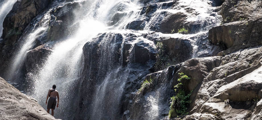
Jerangkang Waterfall
Waterfalls of Malaysia
Jerangkang Waterfall
Jerangkang Waterfall makes up a gorgeous series of cascades and turquoise pools that, in my opinion, is far more worthwhile than its nearby sibling, Berkelah Waterfall. Although you will find huge crowds at the lower levels of both waterfalls, the upper levels of Jerangkang seem to be relatively devoid of people and as such, are far cleaner. Before we proceed any further however, I have to take a moment to make a disclaimer and to urge you to use common sense and caution when doing anything in the vicinity of the waterfall, and especially so when preceded by a bout of rain. Please also jot down the numbers that are listed below. If you do see any suspicious behaviour when out hiking, encounter things like traps and snares, or even see protected animals or their parts that are sold as either collectibles, pets, or for (so-called) medicine, then please do not hesitate to contact the wildlife crime hotline. Be sure to try and document it as best you can with photos or video without putting yourself in danger, and take note of the details: descriptions of those who are involved, as well as when and where it took place.
"The Wildlife Crime Hotline, managed by the Malaysian Conservation Alliance for Tigers (MYCAT), provides YOU an avenue to report offences involving endangered wildlife in Malaysia. We protect the identity of all informants, only key info of the reports are forwarded to the authorities."
Emergency Numbers
Wildlife Crime Hotline 019-356 4194 Wildlife Department 1800 885 151 Kuantan Forestry Department 09–5133 236 Kuantan Hospital 09-5133 333 Kuantan Police Station 09-5135 544 Gambang Police Station 09-5483 222Difficulty Rating : 1.8 / 10.0
(Class 1 - Extremely Straightforward)

Getting There
In order to get to Jerangkang Waterfall, one needs to take the Sri Jaya (exit 827) turnoff if traveling eastward along the Lebuhraya Pantai Timur (LPT) from the city of Kuala Lumpur and then on to the left turning (heading east towards Gambang) after passing the toll booths (same way as Berkelah Waterfall). Drive along this road for 7 kilometres until you reach the junction just before Bungur Lake (at GPS location 3.695810, 102.931526). Turn left here and head north-west for approximately 4 kilometres until you reach the turnoff to Jalan Rambutan 2 on your right (there should be signs here that point in the right direction). Jalan Rambutan 2 heads northward first but swings around to the right, heading in an easterly direction, just after crossing the highway. The road continues on to the back entrance of the Eastbound side of the Gambang R&R, which is where the road ends and the dirt track begins. I have seen ordinary sedans make their way through the dirt track but it can get pretty rough and is just wide enough for one vehicle so you might be forced off the road if you encounter a vehicle coming from the opposite direction. The road from the R&R continues east and then swings north, first crossing a bridge, going straight past a right turn, past a village on the left, and then over the final bridge and on to the campsite. It is only seven kilometres long but the condition of the road keeps your speed low, so it does take a bit of time to get there.
Hiking to the Upper Tiers
The crowds will begin to thin as you make your way up the wide trail that heads off north-east to the second, smaller campsite, just 500 metres ahead. This campsite is sheltered by tall trees and is situated beside a large pool at the base of the waterfall. There is a trail that heads up the slopes of the hill northwards on the right that emerges from the tree line next to the river up above (alternatively, you can follow the banks of the river itself and slowly make your way up the slippery rocks). From here you will have to cross a little stream that joins the river, before continuing your hike upwards. The trail continues on the right side of the river for another 500 metres or so, but lies further in and up the hill from the river (running parallel to it) as it continues its north-eastward course. Occasionally a fork that branches off to the left leads its way back down to the water. Half an hour of walking along the main trail (approximately one kilometre in) from the first campsite will bring you back out to the river where you will find another lovely waterfall tier that is accompanied by a large pool (image below on the left). You have to cross the river here at the shallow section, before continuing along the trail on the left side of the river instead.


360 Panorama

360 Panorama
Route Playback
Suunto Movescount Stats
Waterfalls of Malaysia
Waterfalls of Malaysia


