May 14, 2016
Posted by
Ramon Fadli in
Broadleaf Rainforests,
Camping,
Class 2,
Day Hike,
Forests,
Hiking,
IUCN Protected Category 5,
Malaysia,
Pahang,
Tropical Rainforest,
Waterfalls Berkelah Waterfall
Berkelah Waterfall
PROTECTED STATUS :
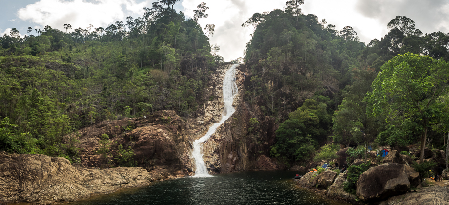
Berkelah Waterfall is one of the most popular waterfalls in Malaysia. The impressive series of multiple cascades that you can find there and its accessibility make it easy to see why that is so. Unfortunately, one is reminded very quickly that with throngs of people comes mounds of rubbish.
Before we proceed any further however, I have to take a moment to make a disclaimer and to urge you to use common sense and caution when doing anything in the vicinity of the waterfall, and especially so when preceded by a bout of rain. Please also jot down the numbers that are listed below. If you do see any suspicious behaviour when out hiking, encounter things like traps and snares, or even see protected animals or their parts that are sold as either collectibles, pets, or for (so-called) medicine, then please do not hesitate to contact the wildlife crime hotline. Be sure to try and document it as best you can with photos or video without putting yourself in danger, and take note of the details: descriptions of those who are involved, as well as when and where it took place.
"The Wildlife Crime Hotline, managed by the Malaysian Conservation Alliance for Tigers (MYCAT), provides YOU an avenue to report offences involving endangered wildlife in Malaysia. We protect the identity of all informants, only key info of the reports are forwarded to the authorities."
Wildlife Crime Hotline019 356 4194
Emergency Numbers
Wildlife Crime Hotline 019-356 4194
Wildlife Department 1800 885 151
Kuantan Forestry Department 09–5133 236
Kuantan Hospital 09-5133 333
Kuantan Police Station 09-5135 544
Gambang Police Station 09-5483 222
*Click here to learn more about the difficulty rating.

Getting There
Berkelah Waterfall is a fairly accessible waterfall as the road that leads to the park entrance is narrow but in decent condition. The bridge that was previously damaged has also been repaired. If traveling eastward along the Lebuhraya Pantai Timur (LPT) from the city of Kuala Lumpur, one should take the Sri Jaya (exit 827) turnoff and turn left (heading east towards Gambang) after passing the toll booths. The road will eventually lead to a junction (at GPS location 3.697989, 102.982568) and turning left to head northwards will bring you along the road that leads straight to the park entrance. The road passes under the highway just before reaching the carpark.
Directions to the junction (at GPS location 3.697989, 102.982568) from the Sri Jaya turnoff (exit 827)
The location of the carpark (3.732705, 102.976304)
Be prepared, as the main entrance of the park is absolutely bustling with families on the weekends. The crowds thin somewhat the further up the trail you go so just keep on walking straight to the small bridge and follow the paved path. After approximately 500 metres, this path meets a small shed where the path abruptly switches to gravel. There are a few crossings over dry riverbeds as you follow the gravel trail. One reaches the first level of the Berkelah Waterfall after about 20 minutes of walking - about 1 kilometre from the first small bridge. The first level consists of a pair of waterfalls that are accompanied by a large pool that is surrounded by a field of boulders. This level's proximity to the park makes it one of the most crowded, especially so with families.
The trail became a little trickier from this point on as it continued past a fence and up the slopes on the west side of the waterfall, before rounding the base and climbing its way to the top of the first level. Here you will come upon the second campsite that sprawls out along the rocks (approximately a 10 minute walk from the base below). Be vigilant if you choose to make camp here though, as rainfall further upstream can cause the water level to rise abruptly, possibly engulfing your campsite.

The trail continues northward up and over rocks with the river on your right. The trail remains on this side of the river all the way until just before the main waterfall. Things can get a little precarious here so be careful and test your footing first before putting your full weight on your step. Try to also stay away from rocks that have a darker greenish or greyish sheen as lichen can begin to form, rendering the rock extremely slippery. You will pass another campsite just ahead and multiple turquoise-coloured pools (that look refreshing and very inviting) almost the entire way up.
 This shot was taken as we made our way back down (with the river on our left)
Just after crossing the river underneath the main waterfall, you will come upon a clearing that is used as a campsite that can easily accommodate a number of tents. The trail then continues upwards to the main waterfall where you can find a few clearings for individual tents scattered around the banks of the dark and deep turquoise pool. There is a large boulder located high up on the right side of the waterfall that provides you with a great vantage point overlooking the waterfall and its pool. If not for its slight downward slant, it would have made a perfect camping spot!
The entire journey from the park entrance to the top level should take you between one and a half to two hours depending on your speed and the number of rest stops you take.
 The slanting rock

Suunto Movescount Stats

 Download GPX file here (right click and save link as)


Hi, are there any marking along the trails? If not, are the upper level trails hard to find, or is there a clearly established path.
There are not many markings but the trail is fairly wide and easy to follow. If you are even in doubt, there are plenty of people around that you can ask. There are however points on the way to the top that are a little rocky but you just need to stay to the side and carefully watch your step. Have fun!