
Langkawi's Giants
Langkawi Index
The Legends Of The Giants
 Langkawi is occasionally referred to as 'Malaysia's Legendary Island' due to the many legends that surround its sights. The legends that visitors to the island are most likely to encounter are Mahsuri's seven-generation curse and the fairies of Telaga Tujuh waterfall. There are far more, however, one of which is the legend of Langkawi's ancient geological formations.
Legend has it that the mountains of Langkawi used to be giants eons ago. Two of these giants, Mat Chinchang and Mat Raya, were good friends whose children were about to be married to one another. During the wedding reception, Mat Raya noticed the son of Mat Chinchang eyeing a completely different woman. This gave rise to a furious argument between the two. Chaos ensued and pots and pans were thrown around. Soon after, another (smaller) giant, Mat Sawar, intervened to try and break up the fight between the two. Unfortunately for all three, lightning then struck and turned all of them into stone.
Langkawi is occasionally referred to as 'Malaysia's Legendary Island' due to the many legends that surround its sights. The legends that visitors to the island are most likely to encounter are Mahsuri's seven-generation curse and the fairies of Telaga Tujuh waterfall. There are far more, however, one of which is the legend of Langkawi's ancient geological formations.
Legend has it that the mountains of Langkawi used to be giants eons ago. Two of these giants, Mat Chinchang and Mat Raya, were good friends whose children were about to be married to one another. During the wedding reception, Mat Raya noticed the son of Mat Chinchang eyeing a completely different woman. This gave rise to a furious argument between the two. Chaos ensued and pots and pans were thrown around. Soon after, another (smaller) giant, Mat Sawar, intervened to try and break up the fight between the two. Unfortunately for all three, lightning then struck and turned all of them into stone.

"The Wildlife Crime Hotline, managed by the Malaysian Conservation Alliance for Tigers (MYCAT), provides YOU an avenue to report offences involving endangered wildlife in Malaysia. We protect the identity of all informants, only key info of the reports are forwarded to the authorities."
Emergency Numbers
Wildlife Crime Hotline 019-356 4194 Wildlife Department 1800 885 151 Langkawi Forestry Department 04–9666 835 Langkawi Hospital 04-966 3333 Langkawi Bomba 04-969 3004 Langkawi Rescue Department 04-966 3434 Langkawi Police Station 04-9666 222Geology of Langkawi
Langkawi has gone through several geological processes since the Early Cambrian period (541 to 509 million years ago); therefore, it comprises of the oldest rock formations in South-East Asia. These processes have left Langkawi blanketed in a wide range of unique structures that are made up of a range of sedimentary rocks. The first process began with sandstone deposits in an environment that is thought to have once been a part of the supercontinent Gondwanaland. These sandstone deposits are what make up the Machinchang Formation. There were numerous other deposits after that, including calcium carbonate-rich sediments that went on to form limestone, as well as signs of glaciation.
Eventually the mass broke away from Gondwanaland and began to drift rapidly towards warmer waters until it eventually collided with Indochina. This collision began in the Upper Permian to Lower Triassic periods (as late as 247 million years ago) and created numerous faults and folds in the area. Magma also slowly solidified underground and gave rise to the Mount Raya granite that is spread out across the central spine of the island. Eventually tectonic uplift carried Langkawi upwards until the three giants broke the surface of the water and emerged from the ocean.
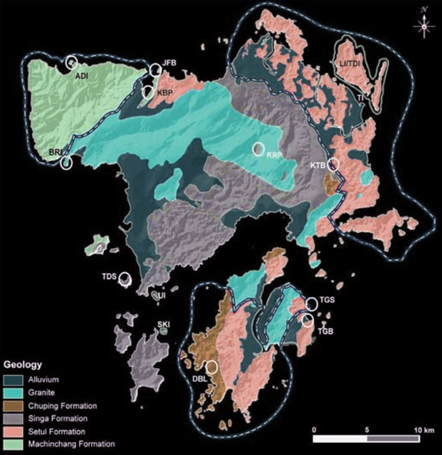
The Geological map above is from the 'Geopark as an answer to Geoheritage Conservation in Malaysia' research paper (colours have been inverted). The map not only indicates the distribution of rock formations around Langkawi, but also marks out significant geosites within and around the Langkawi Geoparks, four of which are geological monuments (LI/TDI, SKI, TI, UI). The key to the Geopark abbreviations can be found below. The boundaries of the three Langkawi Geoparks have also been marked out: Machinchang Cambrian Geoforest Park in the north-west corner; Kilim Karst Geoforest Park in the north-east corner; and Dayang Bunting Marble Geoforest Park in the south.
| Term | Definition | Term | Definition |
|---|---|---|---|
| ADI | Anak Datai Island | RRP | Raya Roof Pendant |
| BRI | Burau Residual Island | SKI | Singa Kecil Island |
| DBL | Dayang Bunting Lake | TDS | Tepur Dropstone |
| JFB | Jemuruk Fossil Bed | TGB | Tuba Granite Boudine |
| KBP | Kubang Badak Pinnacle | TGS | Tuba Granite Sill |
| KTB | Kisap Thrust Breccia | TI | Tikus Island |
| LI/TDI | Langgun Island / Tg. Dendang Island | UI | Ular Island |
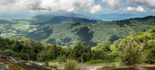
Sawar Hill
Sawar Hill lies between Mount Mat Chinchang and Mount Raya (the interactive location map can be seen here). There is a trail that runs along the spine of the hill, but it is rarely used. The trailhead is located at the side of the road and the trail is quite wide and flat, at least for the first 500 metres or so. After that, the trail swings sharply to the left and begins its ascent. The trail also becomes overgrown fairly quickly. For hiking, I would recommend the other two mountains over Sawar Hill as they are less overgrown and have much better views due to the higher altitudes.
Next : Langkawi (Part 2): Mount Mat Chinchang
Malaysia Overview


