
Mount Stong, Mount Ayam, and Mount Baha
Baha's Camp - Stong Waterfall
Hiking to the Peaks
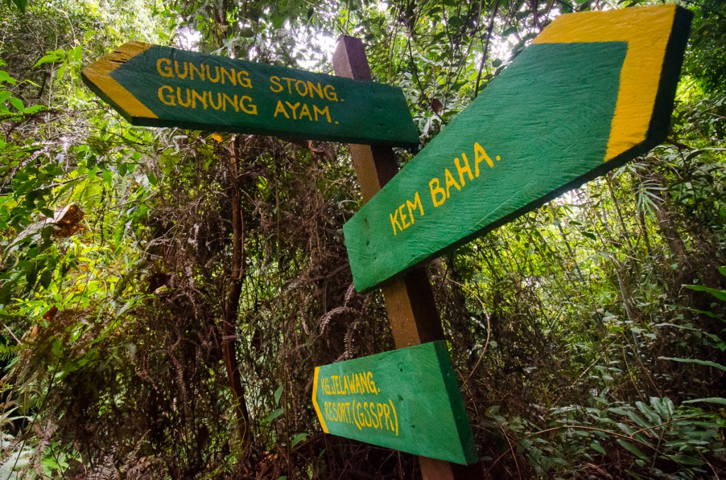
The group had split with Taner, Jenna and I eager to hike to the three peaks whilst the others decided to stay behind and explore the waterfalls. By the time the three of us set off from Baha Camp it was already 10:26. We made our way to the crossroads that lay just outside the campsite quickly to avoid any guides that may still be lingering around the camp just in case they tried to prevent us from heading up to the summits 'unguided'. Once we arrived at the crossroads, we turned left following the signpost that said 'Gunung Stong. Gunung Ayam'.
Before we go on, please jot down the numbers that are listed below. If you do see any suspicious behaviour when out hiking, encounter things like traps and snares, or even see protected animals or their parts that are sold as either collectibles, pets, or for (so-called) medicine, then please do not hesitate to contact the wildlife crime hotline. Be sure to try and document it as best you can with photos or video without putting yourself in danger, and take note of the details: descriptions of those who are involved, as well as when and where it took place."The Wildlife Crime Hotline, managed by the Malaysian Conservation Alliance for Tigers (MYCAT), provides YOU an avenue to report offences involving endangered wildlife in Malaysia. We protect the identity of all informants, only key info of the reports are forwarded to the authorities."
Emergency Numbers
Wildlife Crime Hotline 019-356 4194 Wildlife Department 1800 885 151 Kelantan Forest Territories 09-9556 055 Jeli Health Office 09-9440 333 Jeli Bomba 09-9440 444 Jeli Police Station 09-7867 222Difficulty Rating : 4.2 / 10.0
(Class 5 - Moderate)
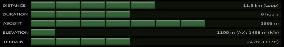
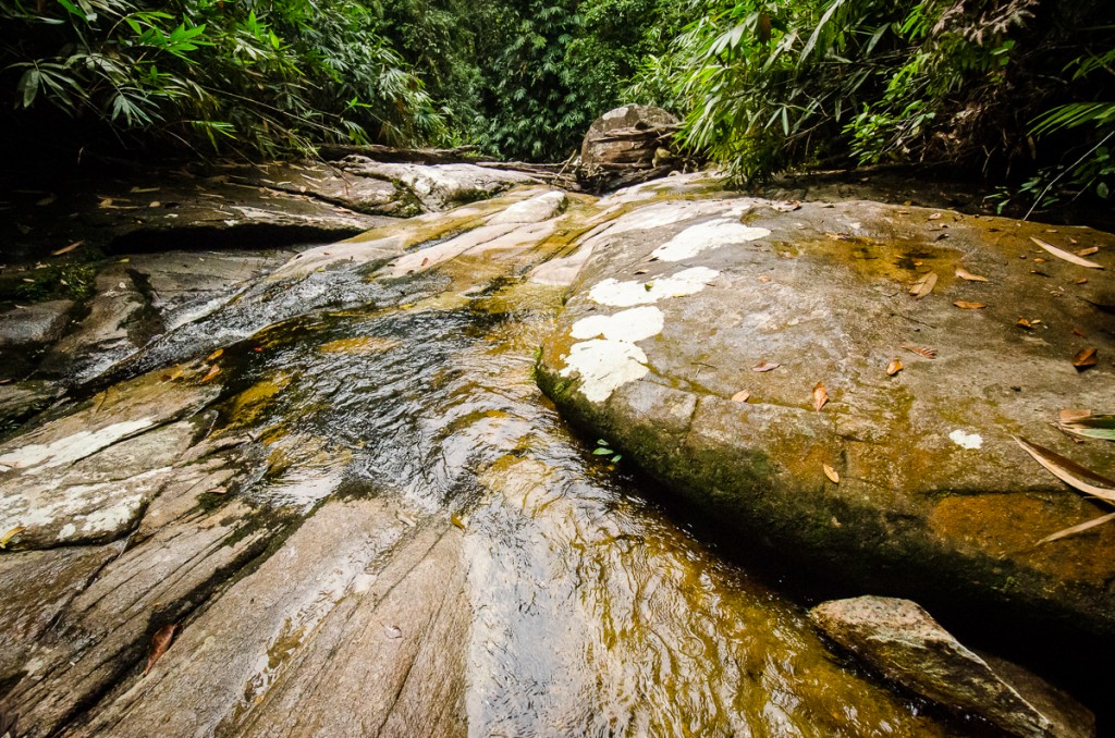
The trail began with a gentle incline of about 20-30 degrees with a yellow (and occasionally almost pinkish) clay-like terrain that plateaued after about 20 minutes or so just before a short descent to the 'Sungai Rantai' river that was used as the first checkpoint (CP1). The combination of the several relatively deep pools along the river, the crystal clear water, and the humidity made the thoughts of just jumping in very tempting. Having only just covered 820 metres, we quickly discarded the notion of swimming and proceeded along the trail.
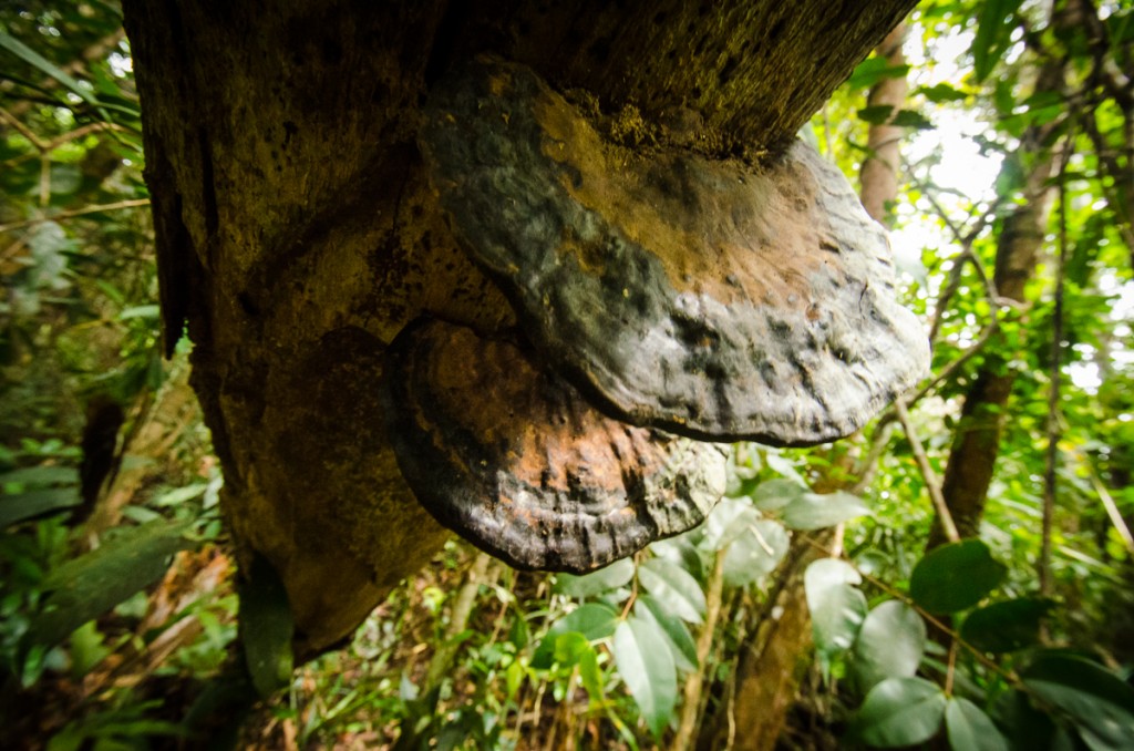
We passed through several sections that had heavy bamboo growths as siamang gibbons (Symphalangus syndactylus) hooted in the distance. After checking (after the fact) however, I found that the two primates that can be found in this region are the Banded leaf-monkey (Presbytis femoralis) and the southern pig-tailed macaque (Macaca nemestrina). The trail lead to a clearing of ferns after about 45 minutes of trekking (distance of 1.9 km) before opening up into a clearing that could potentially be used as a campsite for up to 20 people, that could only be the 'Benta Balak' campsite. Approximately 10 minutes of trekking after this clearing (2.2 km) brought us to the the main junction with the right turning proceeding up to Mount Ayam, and the left to Mount Stong. Interestingly enough on the way up we found the left turning to Stong barred by a long log of sorts, whereas on the way down from Stong several hours later we found the right turning to Ayam barred instead with the same log.
After taking the right turning that continued on northwards, we found our pace severely reduced as we were caught behind a large group that was progressing very slowly. Fortunately we were very close to the river crossing at CP3 (Sungai Baha) and were able to overtake them here. The trek down from the crossroads to CP3 had taken us approximately 15 minutes (distance of 2.4 km and an elevation of 842 m). We stopped for a while at the river crossing as some of the guides asked us a few questions. They seemed concerned at first until I mentioned the fact that Taner had traversed the Titiwangsa range alone from Cameron Highlands to Mount Yong Belar and Mount Korbu and out through Ipoh in only 2 days. The fact that we also took just over an hour to reach CP3 from Baha Camp and that we had two GPS devices amongst us seemed to pacify any fears or concerns that they may have had remaining. We followed the river due west for twenty metres or so before turning right once again to head back into the forest.
Next : Mount Stong, Mount Ayam, and Mount Baha (Part 2)
Malaysia Overview

