
November 19, 2012
Posted by Ramon Fadli in Alpine, Arctic & Antarctic Tundra, Class 5, Glaciers, Peak Labels
EBC Day 12 – Kalapattar
EBC Index
Kalapattar
The day before had been the first day of the entire trip where I would actually have considered myself to have been exhausted. Perhaps that is why my dreams at that point were so vivid.. or maybe it was just the elevation? The dream that I had that night was strange and very muddled, yet was somehow very clear. Some researchers think that the decreased oxygen levels at high elevations somehow affect the recollection of dreams, whilst others think that the shorter sleep cycles make us more likely to wake up during the REM phase. Whatever the reason was, the dream was about time, and I recall watching myself talk to myself about time, as well as discuss the effects and consequences of it. It was also very cold that night, so cold that I had to put off going outside to the outhouse, as anywhere outside my sleeping bag was simply freezing. Fortunately, I did not have to hold it for very long for I was up by 04:00, fresh and ready to tackle the highlight of the EBC trip: Kalapattar
Difficulty Rating : 4.0 / 10.0 (Class 5 - Moderate)
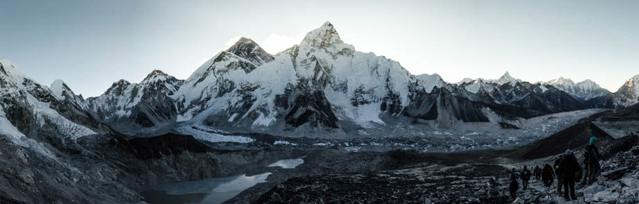
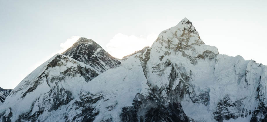
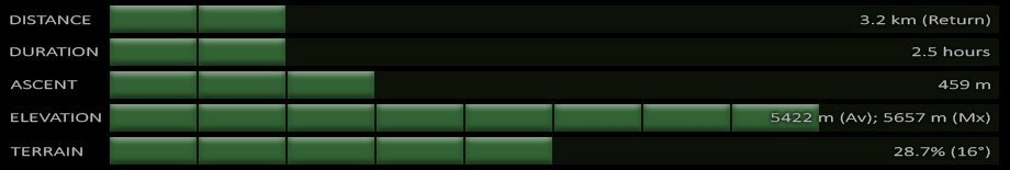 The trail began gently enough with an inclination of around 30 degrees, but it became steeper and steeper as it switch-backed up the hill, closing in to close to 50 degrees or so later on. Jasni's pace had slowed dramatically as we hit the steeper sections, so rather than slowing down (and cooling down) too, I decided to continue on alone. He was safe with his guide after all. My Suunto Ambit was clipped to the outside of my jacket at that point so that the warmth of my body would not interfere with the temperature readings, and the display showed that it was only -10 degrees. There was a brisk wind in the air then and its windchill effect made it feel so much colder. I realised that I had also made a silly mistake, having decided to wear just light cross-trainers since the entire walk would only take two hours or so. But as the wind picked up as I made my way forward, I realised that not only was my face numb, but that my toes were getting quite numb too. Fortunately I was fairly close by then, so I dashed up to the prayer flag-festooned summit as quickly as I could, making it just in time for some sunrise shots. I realised then that this would be the highest point of the entire trip as the high-altitude passes that lay in store for me over the next few days would not surpass an elevation of (5500 m).
Route Playback
Suunto Movescount Stats


Next (Day 12) : Gorak Shep to Dzongla
EBC Index


