
November 7, 2012
Posted by Ramon Fadli in Alpine, Arctic & Antarctic Tundra, Class 8, Hiking, Humid Subtropical, IUCN Protected Category 2, Looped Hike, Mountains, Multiday Hike, National Parks, Nepal, Peak Labels, Pradesh 1, Solo Hike, UNESCO
Everest Base Camp & High-Altitude Passes
EBC Day 01 - Kathmandu Arrival
EBC Day 02 - Kathmandu's Durbar Square
EBC Day 03 - Boudhanath & Pashupatinath
EBC Day 04 - Lukla to Phakding
EBC Day 05 - Phakding to Namche Bazaar
EBC Day 06 - Acclimatisation Day
EBC Day 07 - Namche Bazaar to Tengbouche
EBC Day 08 - Tengbouche to Dingbouche
EBC Day 09 - Acclimatisation at Dingboche
EBC Day 10 - Dingbouche to Lobuche
EBC Day 11 - Everest Base Camp
EBC Day 12 - Kalapattar
EBC Day 13 - Cho La Pass
EBC Day 14 - Gokyo & Gokyo Ri
EBC Day 15 - Gokyo’s 4th & 5th Lake
EBC Day 16 - Renjo La Pass
EBC Day 17 - Lungden to Namche Bazaar
EBC Day 18 - Namche Bazaar to Lukla
Everest Base Camp & High-Altitude Passes
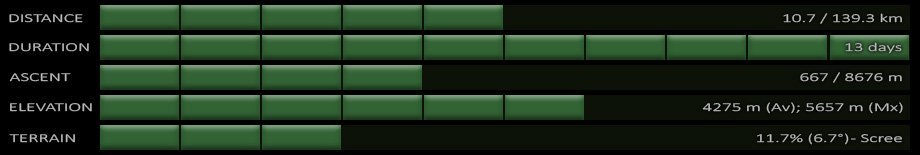
 The Everest Base Camp Trek (commonly referred to as 'EBC) is considered one of the world's classic treks and takes one to the foot of the highest mountain in the world, Mount Everest (elevation : 8848 m). The trek takes at least two weeks with several days of acclimatisation stops, and passes through the world's highest mountain range, the Himalayas. Trekking amongst 'eight-thousanders' provides one with some incredible views of some of the highest mountains in the world. I on the other hand, was looking for something far more remote so that I would be able to escape the ridiculous crowds that one tends to find on the EBC trail. The three high-altitude passes seemed perfect and at that time I thought would be a great side trip from EBC. Little did I know that (underwhelming) 'EBC' would end up being the side trip!
Difficulty Rating : 5.6 / 10.0 (Class 8 - Very Challenging)
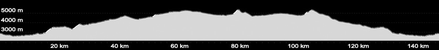
 The route mapping for the high-altitude passes was a little tricky though as the route was not clearly visible on the map, although I was able to determine a rough route but ultimately had to break up the mapped routes into different phases as each route was limited to only 100 points. This turned out to not be an issue however as the navigation was stopped after the end of each daily trek for battery conservation. It also turned out that the 'rough' routes that I had mapped didn't dramatically differ from the actual route taken as can be seen below (Image below - top : Route that was mapped out; bottom : Actual route taken):

The Plan
My original plan was to travel alone without porters and guides, starting the hike by flying in to Lukla and making my way up the classic EBC route. Once reaching Dingboche, I would have veered off to the East towards Chukung in order to climb to the summit of Chukung Ri before crossing the Kong Ma La high-altitude pass. From there I would have made my way north to Everest Base Camp and the summit of Kalapattar, before heading back down to cross the Cho La high-altitude pass for Gokyo, the 5th Lake, and the summit of Gokyo Ri. Then I would have made my way across the Renjo La high-altitude pass and back down to Lukla via Thame. The objective was to cross the three high-altitude passes (Kongma La, Cho La, Renjo La), to climb the three summits (Chukkung Ri, Kalapattar, Gokyo Ri), and to hike up to Everest Base Camp. As is usually the case with all trips, plans change. Ultimately, I did everything that I had intended to do except for the Kongma La high-altitude pass and the Chukkung Ri summit (reasons for which I will go into later).
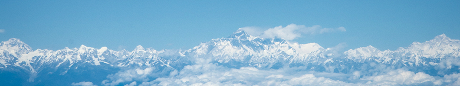
Aerial Shots
Interactive Location Map
The map below has sections of the path that I followed hyperlinked and clicking on each section of the route will bring you to its respective page (if the map does not work for any reason, you may also find the links at the top of this page). The GPS routes for each leg of the journey can also be found at the end of the post for each of the respective days.
- Nepal Day 04 – Flight to Lukla & Trek to Phakding
- Nepal Day 05 – Trek from Phakding to Namche Bazaar
- Nepal Day 06 – Acclimatisation at Namche Bazaar
- Nepal Day 07 – Trek from Namche Bazaar to Tengbouche
- Nepal Day 08 – Trek from Tengbouche to Dingbouche
- Nepal Day 09 – Acclimatisation at Dingboche
- Nepal Day 10 – Trek from Dingbouche to Lobuche
- Nepal Day 11 – Trek from Lobuche to Gorak Shep
- >
- Nepal Day 11 – Everest Base Camp
- >
- Nepal Day 12 – Kalapattar
- Nepal Day 12 – Trek from Gorak Shep to Dzongla
- Nepal Day 13 – Cho La Pass
- Nepal Day 14 – Gokyo & Gokyo Ri
- Nepal Day 15 – Gokyo’s 4th & 5th Lake
- Nepal Day 16 – Renjo La Pass
- Nepal Day 17 – Lungden to Namche Bazaar
- Nepal Day 18 – Namche Bazaar to Lukla
- Nepal Day 19 – Lukla
- Nepal Day 20 – Return to Kathmandhu
Next (Day 1) : Kathmandu Arrival
Nepal Overview


