


February 8, 2013
Posted by Ramon Fadli in Broadleaf Rainforests, Camping, Class 6, Forests, Guided Hike, Hiking, IUCN Protected Category 6, Kelantan, Malaysia, Mountains, Multiday Hike, Tropical Rainforest
Tok Nenek, Bubu, Yong Yap (TNBYY)
Titiwangsa Range
Tok Nenek, Bubu, Yong Yap (TNBYY)
Disclaimer
This hike is one of five entries on this website (out of more than a hundred) that made use of a guide. I personally am a big advocate of independent travel and self-guided hiking that does not require guides or porters. My reasoning is as follows (in no particular order): Less costly: Aside from the cost of permits, self-guided hiking has no guide expenses that need to be covered, and hikers also have full control over the cost of their meals. Guide expenses tend to normally be shared out amongst the group, which means that the larger the group, the less each hiker will have to pay. Less environmental impact: Without the burden of guide expenses, group sizes can be kept much lower. Small groups tend to be far more mobile and significantly reduce their impact to trails and campsites. Large groups also have a profound impact on other groups that are sharing the trail. I personally feel that groups of more than 4 or 5 people tend to be too large. Read up on Leave No Trace (LNT) principles for more info. More independence: Self-guided hiking requires hikers to be knowledgeable in multiple skills--navigation and route-finding, survival techniques, and wilderness medical skills just to name a few. It requires a level of fitness that allows hikers to be fully independent and to be able to carry all the gear that they will need without requiring the services of porters. Hikers that are unprepared should simply not be allowed on the trails. The trails are currently overloaded with hikers who should not be there in the first place. High customisability: One of the best things about independent travel is researching the location prior to the trip. This inevitably means that you will know far more about the area that is traveled through compared to someone who just goes in blindly expecting the guide to handle everything. You get full control over the planning of the route as well as developing contingency plans in situations such as inclement weather or medical emergencies. You also get to determine your own pace and can choose to stop if you need a moment of peaceful reflection. Who wouldn't want to enjoy nature on their own terms?"The Wildlife Crime Hotline, managed by the Malaysian Conservation Alliance for Tigers (MYCAT), provides YOU an avenue to report offences involving endangered wildlife in Malaysia. We protect the identity of all informants, only key info of the reports are forwarded to the authorities."
Emergency Numbers
Wildlife Crime Hotline 019-356 4194 Wildlife Department 1800 885 151 Lojing Police Station 09-9221403- Arrangement of activities
- Certified Outward Bound Trekkers Guide
- Trekking Permit
- Camping Equipment
- Kitchen Equipment
- Foods & Beverages
- Moisture Wicking T-Shirt
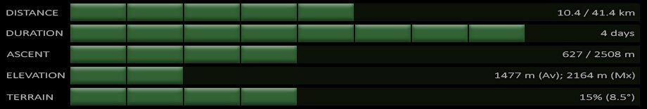
Difficulty Rating : 4.6 / 10.0
(Class 6 - Fairly Challenging)
Interactive Location Map
Continue on to the entries for each day by clicking on their respective sections on the map below(if the map does not work for any reason, you may also find the links at the top of this page).
Next : Tok Nenek, Bubu, Yong Yap (TNBYY) – Day 1
Mountains of Malaysia
Malaysia Overview
")
 - Day 2")
 – Day 3")
")