
Mount Tok Nenek (Single)
Titiwangsa Range
The TNBYY Loop
Disclaimer
This hike is one of five entries on this website (out of more than a hundred) that made use of a guide. I personally am a big advocate of independent travel and self-guided hiking that does not require guides or porters. My reasoning is as follows (in no particular order): Less costly: Aside from the cost of permits, self-guided hiking has no guide expenses that need to be covered, and hikers also have full control over the cost of their meals. Guide expenses tend to normally be shared out amongst the group, which means that the larger the group, the less each hiker will have to pay. Less environmental impact: Without the burden of guide expenses, group sizes can be kept much lower. Small groups tend to be far more mobile and significantly reduce their impact to trails and campsites. Large groups also have a profound impact on other groups that are sharing the trail. I personally feel that groups of more than 4 or 5 people tend to be too large. Read up on Leave No Trace (LNT) principles for more info. More independence: Self-guided hiking requires hikers to be knowledgeable in multiple skills--navigation and route-finding, survival techniques, and wilderness medical skills just to name a few. It requires a level of fitness that allows hikers to be fully independent and to be able to carry all the gear that they will need without requiring the services of porters. Hikers that are unprepared should simply not be allowed on the trails. The trails are currently overloaded with hikers who should not be there in the first place. High customisability: One of the best things about independent travel is researching the location prior to the trip. This inevitably means that you will know far more about the area that is traveled through compared to someone who just goes in blindly expecting the guide to handle everything. You get full control over the planning of the route as well as developing contingency plans in situations such as inclement weather or medical emergencies. You also get to determine your own pace and can choose to stop if you need a moment of peaceful reflection. Who wouldn't want to enjoy nature on their own terms?"The Wildlife Crime Hotline, managed by the Malaysian Conservation Alliance for Tigers (MYCAT), provides YOU an avenue to report offences involving endangered wildlife in Malaysia. We protect the identity of all informants, only key info of the reports are forwarded to the authorities."
Emergency Numbers
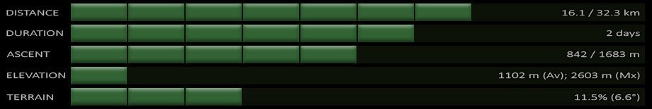
Wildlife Crime Hotline 019-356 4194 Wildlife Department 1800 885 151 Lojing Police Station 09-9221403Difficulty Rating : 4.4 / 10.0
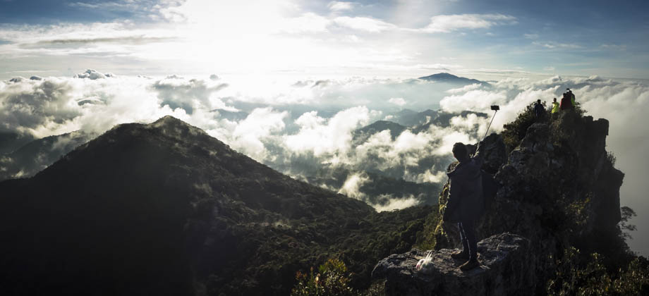
(Class 6 - Fairly Challenging)
Getting There
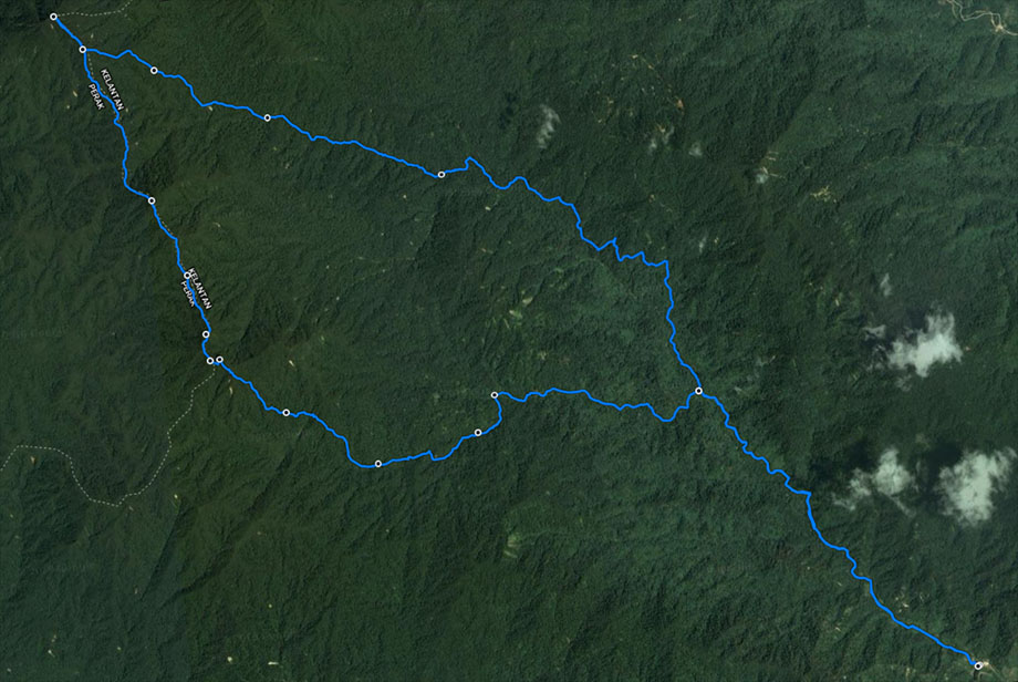
To get to the trailhead, head to the main Blue Valley junction that is located just north of the small town of Kampung Raja in Cameron Highlands. From here turn right to head north-east, past all the farms, towards the town of Lojing. After approximately 15 minutes of driving, you'll come across a turnoff on your left that leads to the start of the unsealed road that heads up to Pos Rengil. The unsealed road itself is just over 2 kilometres long and ends at a dirt clearing where you can park your car. The trailhead lies just after the bridge next to the carpark.
The Annual Rhododendron Hike
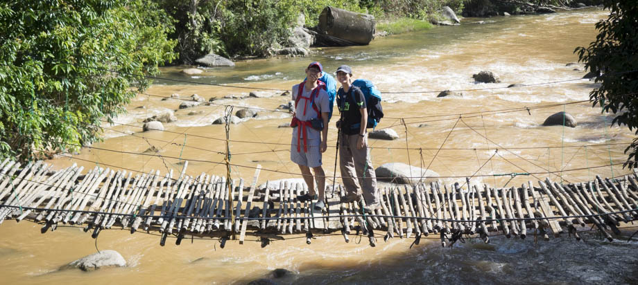
Our large group made our way up to the trail head at Pos Rengil early that Saturday morning, distributed fairly evenly amongst the entire convoy of cars. The last time I was there was four years ago, so I found myself surprised to see that the unsealed road that lead up to the village had since been paved. The improvements were so significant that 4WD cars were no longer required for access. A clearing had also been leveled off to make space for a car-park and a new (much larger) metal bridge now spanned the wide river, and lay parallel to the old and rickety bamboo bridge that was somehow still standing. The group was there as part of the annual TAROH (The Annual Rhododendron Hike) event by HACAM, a yearly hike that usually occurs in the early months of the year, and our objective was to search for the newly blossoming rhododendrons (Rhododendron spp.). The Rhododendron genus is huge (with over 1000 species) and bewilderingly diverse. Most of the species that are found in the Malaysian wilderness tend to be epiphytic and usually occur in the mossy forests that are scattered along the mountain ranges in Peninsular Malaysia, with some species having a tendency to be found on more exposed areas such as mountain summits and ridges. Malaysia is one of the centres of diversity for the Rhododendrons (the other being the Himalayas), which means that it is one of the areas where Rhododendrons first developed their distinctive properties. As such, the country hosts species of all shapes and sizes: some hang from tree limbs, and some are small trees themselves; some emerge in puffy bunches, and some are long and vine-like. Even the fertilisation methods are staggeringly diverse with some species that are located at higher elevations having down-slanted flowers for their pollinators, nectar-eating birds; some of the ones lower down are highly scented and have very narrow corolla tubes that are so long that only the long proboscis of hawk-moths (Family: Sphingidae) and other lepidopters can access.
Next : Mount Tok Nenek Single (Part 2 - Setting Off)
Malaysia Overview
")
 – Day 3")
 - Day 2")
 - Day 1")