Mount Berembun
Trail 5 & 7
Difficulty Rating : 2.8 / 10.0
(Class 3 - Straightforward)

Trail 5
The plan was to head up to the summit via trail 5 and to head back down via trail 7, both starting and ending at the MARDI Agro-Technology Park. To get to the trail heads for both 5 & 7, we kept left once we entered the MARDI gate and walked up the hilly road. The trail head for trail 7 lay almost straight ahead alongside the Camellia apartments but we needed to swing left instead to get to the trail head for trail 5.
The trail took us up some steps and through some lettuce patches (Lactuca sativa) before curving right to plunge into the forest. The trail here was completely covered in a tunnel of undergrowth, a tunnel that was not quite covered by a canopy but rather of sides that closed in overhead. The area here was still devoid of moss as the elevation (elevation : 1450 m) was relatively low. Epiphytes began to appear however, after passing some incongruous poles and a gradual climb approximately 600 metres in, but the trail erosion also became more apparent as roots that lined the trail became more exposed. Deep trenches left behind by water channels were also far more common here. Our group took our time and restored as much as we could with the resources that we had before continuing on.
We were stopped by a large fallen tree almost one kilometre into the trail and were forced to make a slight diversion off to the left. It was quite apparent that others before us had done the same as the trail was beginning to widen here, basically another form of trail erosion. The trail leveled somewhat soon after just before making a little climb to the top of a little hill and descending back down to the 1.3 km mark. The path veered north from here as it began to make its way up to the shelter junction.

Just before we reached the junction however, we encountered another obstacle--another fallen tree trunk. This tree trunk was much smaller than the previous one so we spent some time cutting through the exposed branches and doing our best to clear the trail and minimise potential hazards. The shelter junction lay within sight just ahead, with the trail continuing straight to trail 3, left to trail 6, and the summit of Mount Berembun approximately an hour away to the right.
After a short rest at the shelter, we continued on down the right turning with the trail first dipping down into a small valley before climbing back up the shoulder. The incline here was a gradual climb for the first 300 metres before becoming a lot steeper around the 2 km mark. This first climb was a fairly short one (approximately 100 metres or so) as the trail leveled off for a bit before climbing once again 2.4 km in. The summit of Mount Berembun (elevation : 1840 m) was reached 700 metres later (3.1 km mark) and after passing two small clearings.
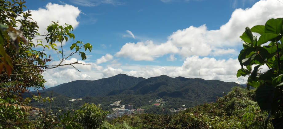
Just beyond the triangulation point lay a small opening in the canopy that presented us with a glimpse [cover photo] of the other mountains that lay to the north-west. There were two distinctive peaks: Mount Brinchang (elevation : 2031 m) on the right with its jumble of communication towers rising up to the sky; and the triangular peak of Mount Irau (elevation : 2110 m) behind and to the left.

Trail 7
Continuing straight along the trail from the summit brought us on to trail 7. The descent took us through ubiquitous fronds and ferns, with a backdrop of bamboo shoots (Tribe : Bambuseae) that were so straight that they seemed to have burst from the ground. We made our way down almost directly due south at first but the trail veered westward soon after. The trail continued to descend down the slopes of the mountain, only broken by a clearing at the 3.8 km mark, and gradually began to level out approximately 4.4 km in, just 700 metres from MARDI, where we began.
As we approached the end, the moss began to melt away and the path closed in for a bit before dropping and swerving right into the strawberry (Fragaria × ananassa) farm at the end. Edging the hill brought us around to the back of the apartments and down the back road of MARDI Agro-Technology Park.
Route Playback