
Mount Berembun
Cameron Highlands Index
Mentigi Soil Protection - Forest Reserve - Category 1b
Mount Berembun
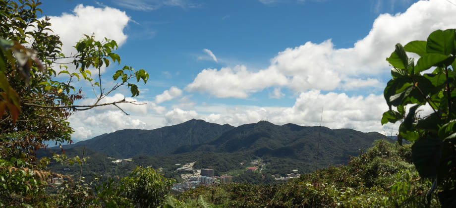
Mount Berembun (elevation : 1840 m) is one of the more interesting mountains to climb in Cameron Highlands as there are plenty of trails (most of which are shown in the image below) to choose from that start at different points around town. The fact that it is also the closest summit to one of the only camping spots that is readily available in this area, Sungai Pauh Campsite (also known as the Forestry Department campsite), makes it especially convenient for hikers. Before we go on, please jot down the numbers that are listed below. If you do see any suspicious behaviour when out hiking, encounter things like traps and snares, or even see protected animals or their parts that are sold as either collectibles, pets, or for (so-called) medicine, then please do not hesitate to contact the wildlife crime hotline. Be sure to try and document it as best you can with photos or video without putting yourself in danger, and take note of the details: descriptions of those who are involved, as well as when and where it took place.
"The Wildlife Crime Hotline, managed by the Malaysian Conservation Alliance for Tigers (MYCAT), provides YOU an avenue to report offences involving endangered wildlife in Malaysia. We protect the identity of all informants, only key info of the reports are forwarded to the authorities."
Emergency Numbers
Wildlife Crime Hotline 019-356 4194 Wildlife Department 1800 885 151 Cameron Highlands Forestry Department 09–3551 060 Cameron Highlands Hospital 05-4911 966 Cameron Highlands Bomba 09-4911 003 Tanah Rata Police Station 05-4915 443 Ringlet Police Station 05-4956 222 Kg. Raja Police Station 05-4981 222 JKR Cameron Highlands 05-4911 105Getting There
In order to get to the Sungai Pauh Campsite, you need to make your way north from the main area of Tanah Rata and just after the Smokehouse Hotel (just before the Cameron Highlands Golf Course), you will reach a junction where you will need to turn right that has a huge sign that says 'Iris House Resort'. The road will lead to a tiny roundabout where a right turn there will bring you to the Forestry Department (Jabatan Hutan) on the left fork of the road. Go past the guard booth and make another left turning that winds its way down a narrow road until you can go no further. Park alongside the road as the campsite is just a short walk from this point.
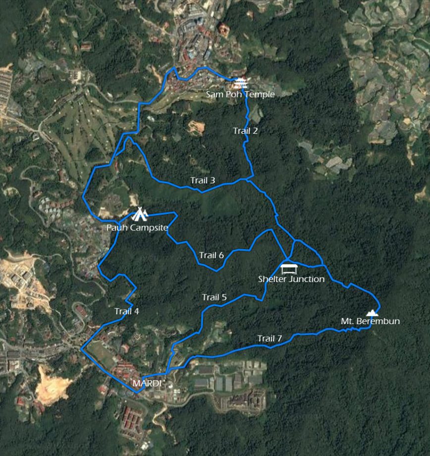
Trail Map
The more common trails that lead up to the summit are highlighted below. There are a few others but they have either been closed off or are not recommended due to safety issues. Have a look and plan your journey based on where you plan to start and finish, and I will cover the trails themselves in the following pages.
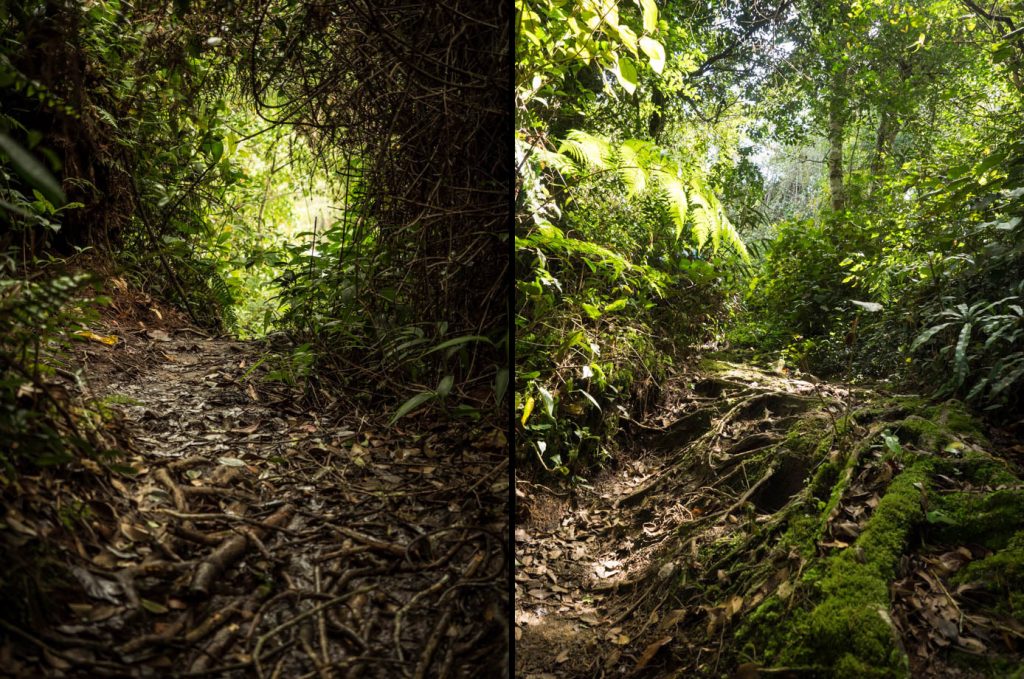
Trail Erosion
 I just want to cover trail erosion briefly since (on this occasion) I was there not as a guide for a hike, but for trail restoration. The biggest issue with hiking, in my opinion at least, is the impact that hikers leave when both camping and hiking. This is why I am firm advocate of the 'Leave No Trace' (LNT) ethos and feel that absolutely everyone who spends their time in the wilderness should be responsible enough to abide by the LNT principles. We all need to work together to protect nature and ensure that it is left in a better state than it was originally found.
Erosion is something that occurs naturally and is a process when 'permanent fixtures' such as soil and rock are worn away by water flow and wind. Unfortunately the traffic that trails get also contributes to trail erosion. When this erosion is left unchecked, the trails and the surrounding environment can be left severely damaged. Water that begins to flow through a channel for instance, begins to cut through the soil, deepening the channel in the process and ultimately causing riles and gullies. More water begins to accumulate and as the water volume starts to build up, so does the velocity and energy of the flow. This can cause significant damage as the surface runoff of water can also wash away the nutrition-dense and fertile topsoil, without which little plant life is possible.
I just want to cover trail erosion briefly since (on this occasion) I was there not as a guide for a hike, but for trail restoration. The biggest issue with hiking, in my opinion at least, is the impact that hikers leave when both camping and hiking. This is why I am firm advocate of the 'Leave No Trace' (LNT) ethos and feel that absolutely everyone who spends their time in the wilderness should be responsible enough to abide by the LNT principles. We all need to work together to protect nature and ensure that it is left in a better state than it was originally found.
Erosion is something that occurs naturally and is a process when 'permanent fixtures' such as soil and rock are worn away by water flow and wind. Unfortunately the traffic that trails get also contributes to trail erosion. When this erosion is left unchecked, the trails and the surrounding environment can be left severely damaged. Water that begins to flow through a channel for instance, begins to cut through the soil, deepening the channel in the process and ultimately causing riles and gullies. More water begins to accumulate and as the water volume starts to build up, so does the velocity and energy of the flow. This can cause significant damage as the surface runoff of water can also wash away the nutrition-dense and fertile topsoil, without which little plant life is possible.
Next : Berembun (Part 2): Epic Epiphytes
Malaysia Overview


