
Lugnaquilla
Blanket Bogs
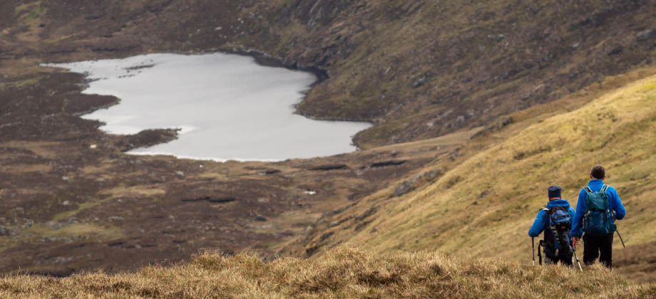
As the dirt track rounded the hill, it slowly curved westward once again, and ran alongside the slopes of Carrawaystick (elevation : 728 m) towards the south. We began to approach Kelly's Lough soon after, as well as a fence that ran up the side of the hill. We veered left here (7.5 km mark), and began to walk up the slopes using the fence as a handrail. We were now within the boundaries of the Wicklow National Park. At the top of the hill, we merged with the Corrigasleggaun-Carrawaystick trail (8.2 km mark), and turned right to head westward once again.
The terrain here was completely dominated by blanket bog, which is essentially areas of peatland. Peat is formed in waterlogged areas when plants do not completely decompose. Rainfall causes minerals such as iron to be washed away to lower and lower depths, and they eventually form a layer that is known as an iron pan. This layer is impermeable and causes the soil above to become waterlogged as a result. Over time, the partially decomposed plants on the surface begin to accumulate and 'grow'. This growth can be up to one millimetre a year, but over long periods, can even reach depths of several metres.

Peatland is the most efficient carbon sink on the planet. This is because the growth of plants in the area exceeds the rate at which dead plants decompose. This means that the carbon dioxide that is naturally released from the peat is captured and essentially 'stored' within the living plants. There have been instances in the Wicklow mountains where blanket bogs are drained for the purpose of preparing land for commercial forests. This creates huge ecological changes to the area, as bog plants eventually disappear and release the stored carbon dioxide in the process.

Sphagnum mosses are easily the most important of all the bog plants. These highly-specialized plants have huge absorption capabilities, and are able to hold up to ten times their weight in water. Their sponge-like properties (as well as the aforementioned iron pan layers) is what makes blanket bog areas so waterlogged. Sphagnum mosses also acidify the water that runs through them by holding onto plant nutrients, which in turn further decreases the rates of decomposition. These mosses essentially 'float' upon the waterlogged, partially decomposed layer of plants beneath. This is what makes the ground feel bouncy as you walk upon it.
Summit Plateau
Once we had climbed out of the valley from Kelly's Lough and had merged with the Corrigasleggaun-Carrawaystick trail, the walk was basically a relaxing saunter up the eastern slopes of Corrigasleggaun (elevation : 794 m). From there, the trail swung northward and continued along to the junction (located just under the 11 km mark) where the trail continued west to Lugnaquilla, east to Cloghernagh, and south back to Corrigasleggaun.


The summit of Lugnaquilla (elevation : 925 m) is fairly unique as it is a wide, flat, fairly bare plateau that is covered with wind-swept vegetation. The summit plateau is also known as 'Percy's Table', which was apparently derived from the lands' 18th–century owner, Colonel Percy. As we walked westward up the slopes towards the summit plateau, we were able to appreciate the two steep glacial corries on the north and south of the plateau, referred to as the North and South Prisons. The South Prison looked into the Glen of the River Ow, and the river itself could be seen meandering away in the distance towards the forests in the south. The North Prison, on the other hand, looked into the Glen of Imaal. This is the location of a military firing range, and as such, the valley is closed off to walkers due to the dangers of both the firing that takes place as well as possible unexploded ordnance. From there it was a straightforward walk to the trig pillar that marked the peak of Lugnaquilla (12 km mark).


