


Annapurna Base Camp & Poon Hill
ABC Day 01 - Pokhara
ABC Day 02 - Nayapul to Ulleri
ABC Day 03 - Ulleri to Ghorepani
ABC Day 04 - Poon Hill
ABC Day 05 - Banthanti to Chomrong
ABC Day 06 - Chomrong to Bamboo
ABC Day 07 - Bamboo to Deurali
ABC Day 08 - Machapuchare Base Camp
ABC Day 09 - Annapurna Base Camp
ABC Day 10 - Chomrong to Nayapul
Annapurna Base Camp & Poon Hill

Difficulty Rating : 5.0 / 10.0 (Class 7 - Challenging)

Interactive Location Map
The map below has sections of the path that I followed hyperlinked and clicking on each section of the route will bring you to its respective page (if the map does not work for any reason, you may also find the links at the top of this page). The GPS route can also be found at the end of this page.
- ABC Day 02 – Nayapul to Birethanti
- ABC Day 02 – Birethanti to Ulleri
- ABC Day 03 – Ulleri to Ghorepani<
- ABC Day 04 – Poon Hill
- ABC Day 04 – Ghorepani to Banthanti
- ABC Day 05 – Banthanti to Chomrong
- ABC Day 06 – Chomrong to Bamboo
- ABC Day 07 – Bamboo to Deurali
- ABC Day 08 – Deurali to MBC
- ABC Day 09 – ABC
- ABC Day 10 – Banthanti to Kyumi
- ABC Day 10 – Kyumi to Birethanti

Annapurna Conservation Area
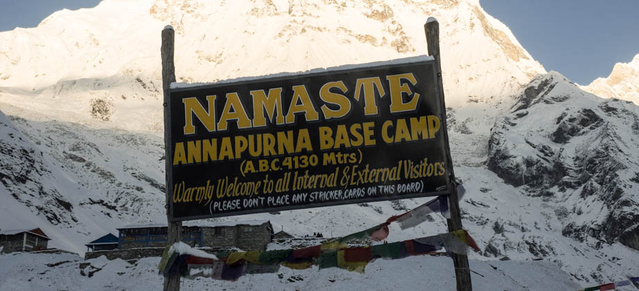
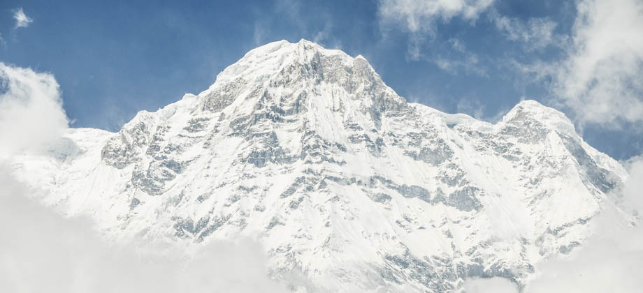
The Annapurna Conservation Area is Nepal's first and largest conservation zone, and has been set up to protect the Annapurna massif and the biodiversity-rich areas that surround it (entry into which requires an ACAP permit). This initiative is quite vital as the number of tourists that have flocked to this region has soared over the years--the region currently attracts about 60% of the total number of trekkers that visit Nepal. This is not only due to the cultural and natural richness of the region, but also because of its accessibility; the range is so close to the city of Pokhara that trekkers are able to reach Annapurna Base Camp (elevation : 4130 m) in just a matter of days.
This surge in popularity has resulted in the establishment of thousands of guesthouses [I intentionally choose to use the term 'guesthouse' instead of 'teahouse' to distinguish between lodges that cater to trekkers and the authentic Nepali teahouses], as well as other services to accommodate the trekkers' whims and fancies. The consumption of wood in the region stresses forest resources, and to make matters worse, visiting trekkers consume multiple times more wood, either directly or indirectly, than the locals do.
The amount of litter that is generated is another matter of concern. It is estimated that an average trekking group of 15 trekkers generates about 15kg of non-biodegradable waste on a 10-day trek, which amounts to tonnes of waste produced in the mountains annually. As such, the reduction of my ecological footprint when in the mountains was of paramount importance to me. So to keep it low, I decided to do the following:
Reducing your footprint
1 - Treating water - I generally use a combination of UV-sterilisers (such as the Adventurer Opti Water Purifier), water filters, and water-purification tablets in order to treat water. This ensures that I do not need to purchase bottled water (which should be the very last option due to the single-use plastic packaging), or boiled water from either the lodges or filling stations, as it can be fairly hard to determine whether the fuel that is used to boil the water contributes to deforestation.
2 - Minimising purchases - Most guesthouses rent out their accommodation for paltry sums, but the difference is made up for in their exorbitant food prices. In the mountains, the rule is you eat where you sleep. With this in mind, I always had dinner in the guesthouse that I slept in. I minimised the purchase of cooked meals by ensuring that I checked in after lunchtime, and most often than not, left whilst everyone else was eating breakfast.
3 - Cooking with a gas stove - After setting off on the trail in the morning, I would normally find a quiet corner and make a quick cup of coffee with my Jetboil Zip and have some muesli whilst taking in the wonderful views. I was especially careful to not let anyone from the guesthouses know that I even carried a stove as it represents a loss of income for them. I also never ever used the stove indoors as most of the lodges are made of wood and doing so would be an immense fire hazard.
Next : ABC Index (Part 2) - Equipment
Nepal Overview


