


Annapurna Circuit
ACT Day 01 - Ngadi to Srichaur
ACT Day 02 - Srichaur to Tal
ACT Day 03 - Tal to Danakyu
ACT Day 04 - Danakyu to Thanchok
ACT Day 05 - Thanchok to Dhikur Pokhari
ACT Day 06 - Dhikur Pokhari to Ngawal
ACT Day 07 - Route to Kang La
ACT Day 08 - Ngawal to Khangsar
ACT Day 09 - Khangsar to Tilicho Base Camp
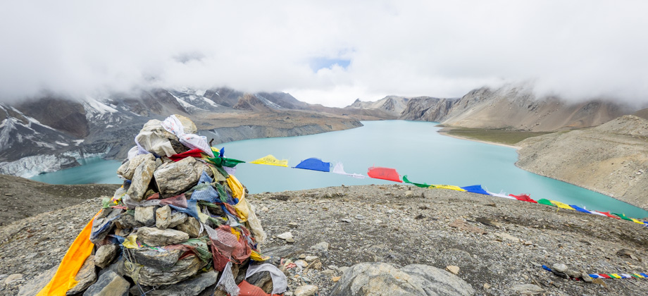
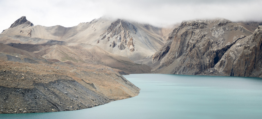
ACT Day 10 - Tilicho Lake
ACT Day 11 - To Yak Kharka
ACT Day 12 - Yak Kharka to High Camp
ACT Day 13 - Thorong La Pass
ACT Day 14 - Ranipauwa to Kagbeni
ACT Day 15 - Kagbeni to Jomsom
ACT Day 16 - Jomsom to Pokhara
The Annapurna Circuit
Difficulty Rating : 5.2 / 10.0 (Class 7 - Challenging)
 Noticed that I mentioned that it used to be considered one of the most beautiful hikes in Nepal? This is because since then, roads have and are still being built around the Annapurna Circuit and have encroached upon it all the way up to Muktinath
 Interactive Location Map
The map below has sections of the path that I followed hyperlinked and clicking on each section of the route will bring you to its respective page (if the map does not work for any reason, you may also find the links at the top of this page). The GPS routes for each leg of the journey can also be found at the end of the post for each of the respective days.
- Annapurna Base Camp
- Kathmandu Preparation
- ACT Day 01 - Ngadi to Srichaur
- ACT Day 02 - Srichaur to Tal
- ACT Day 03 - Tal to Danakyu
- ACT Day 04 - Danakyu to Thanchok
- ACT Day 05 - Thanchok to Dhikur Pokhari
- ACT Day 06 - Dhikur Pokhari to Ngawal
- ACT Day 07 - Route to Kang La
- ACT Day 08 - Ngawal to Khangsar
- ACT Day 09 - Khangsar to Tilicho Base Camp
- ACT Day 10 - Tilicho Lake
- ACT Day 11 - Tilicho Base Camp to Yak Kharka
- ACT Day 12 - Yak Kharka to High Camp
- ACT Day 13 - Thorong La
- ACT Day 14 - Ranipauwa to Kagbeni
- ACT Day 14 - Tiri
- ACT Day 15 - Kagbeni to Jomsom
- The Descent

over the image below will reveal highpoints ). The Annapurna Base Camp
section has not been included in the elevation profile
The Plan
The plan this time around was not only to test out these NATT routes and to trek the Annapurna Circuit before the roads completely destroyed the region but also to hike during the monsoon season. Despite the central parts of the circuit being deep within the rain shadow that is cast by the Annapurna massif, trekking the circuit in the monsoon still poses its own set of challenges. I did however find that there were also some very obvious advantages:
Advantages
1) Since the Annapurna Circuit is one of the most popular and well-beaten trails in the whole of Nepal, it indubitably attracts hoards of tourists. Hiking in the low-season avoids these trekker 'conveyor belts' and will give you a lot more space to breathe.
2) The lack of crowds makes it easier to get rooms. If you avoid the large villages and stop at the 'satellite hamlets' like we did, there is a high chance that you will be the only guest at the guesthouse. In fact, out of the 15 days during which we were up in the mountains, we had the guesthouse to ourselves for 10 of them. This way, you will definitely be able to negotiate for cheaper rates. We decided to purchase breakfast, instead of eating the food we had brought along, at the guesthouses that decided to waive the accommodation costs (which were at least half of them).
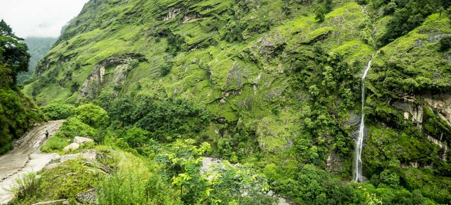
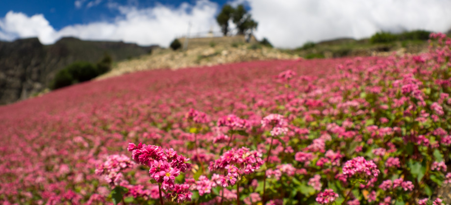
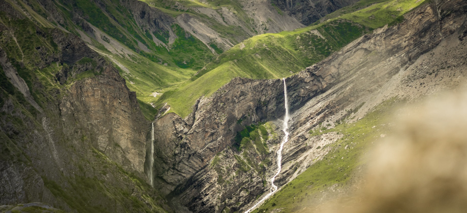
3) The plentiful rain brings with it never-ending and beautifully vibrant wildflowers and ubiquitous waterfalls. The volume of water was so high that the torrential waterfalls caused the river below to churn with dramatic violence.
Disadvantages
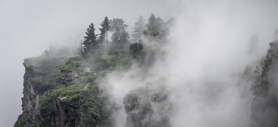
1) The rain clouds and incessant mist obscured the views of the mountains more often than we would have liked.
2) Leeches. To be fair, we were only attacked by leeches on one out of the 15 days. Nonetheless, we were still left with 50-60 bites all over our ankles.
3) Landslides were very prevalent. Although this does not affect walking access on the trails all that much, it is a significant obstacle to vehicles. When planning your descent down the mountain by vehicle, please do take this into consideration.
Challenges
I also decided to set a few challenges for myself. The first was to enter and exit the range by using public buses only: I had heard from several different sources that there were syndicates that controlled vehicular access to the roads, and that apparently these syndicates imposed fees on certain types of vehicles, and were even inclined to use force against those who refused to comply. I could not find a way to verify this information and thus decided to just avoid the 4WD services that could be found in most of the towns. I also decided to bring a completely different set of Olympus lenses for my camera: instead of the Olympus M.Zuiko Digital ED 12-40mm f/2.8 PRO and Olympus M.Zuiko Digital ED 60mm f/2.8 Macro (my go-to combination for outdoor activities), I brought the Olympus M.Zuiko Digital ED 8mm f/1.8 FE PRO and Olympus M.Zuiko Digital ED 75mm f/1.8, two much faster but highly-specialised prime lenses.
Annapurna Conservation Area
The Annapurna Conservation Area is Nepal's first and largest conservation zone, and has been set up to protect the Annapurna massif and the biodiversity-rich areas that surround it (entry into which requires an ACAP permit). This initiative is quite vital as the number of tourists that have flocked to this region has soared over the years--the region currently attracts about 60% of the total number of trekkers that visit Nepal. This is not only due to the cultural and natural richness of the region, but also because of its accessibility; the range is so close to the city of Pokhara that trekkers are able to reach Annapurna Base Camp ![]() (elevation : 4130 m) in just a matter of days.
(elevation : 4130 m) in just a matter of days.
This surge in popularity has resulted in the establishment of thousands of guesthouses [I intentionally choose to use the term 'guesthouse' instead of 'teahouse' to distinguish between lodges that cater to trekkers and the authentic Nepali teahouses], as well as other services to accommodate the trekkers' whims and fancies. The consumption of wood in the region stresses forest resources, and to make matters worse, visiting trekkers consume multiple times more wood, either directly or indirectly, than the locals do.
The amount of litter that is generated is another matter of concern. It is estimated that an average trekking group of 15 trekkers generates about 15kg of non-biodegradable waste on a 10-day trek, which amounts to tonnes of waste produced in the mountains annually. As such, the reduction of my ecological footprint when in the mountains was of paramount importance to me. So to keep it low, I decided to do the following:
Reducing your footprint
1 - Treating water - I generally use a combination of UV-sterilisers (such as the Adventurer Opti Water Purifier), water filters, and water-purification tablets in order to treat water. This ensures that I do not need to purchase bottled water (which should be the very last option due to the single-use plastic packaging), or boiled water from either the lodges or filling stations, as it can be fairly hard to determine whether the fuel that is used to boil the water contributes to deforestation.
2 - Minimising purchases - Most guesthouses rent out their accommodation for paltry sums, but the difference is made up for in their exorbitant food prices. In the mountains, the rule is you eat where you sleep. With this in mind, I always had dinner in the guesthouse that I slept in. I minimised the purchase of cooked meals by ensuring that I checked in after lunchtime, and most often than not, left whilst everyone else was eating breakfast.
3 - Cooking with a gas stove - After setting off on the trail in the morning, I would normally find a quiet corner and make a quick cup of coffee with my Jetboil Zip and have some muesli whilst taking in the wonderful views. I was especially careful to not let anyone from the guesthouses know that I even carried a stove as it represents a loss of income for them. I also never ever used the stove indoors as most of the lodges are made of wood and doing so would be an immense fire hazard.
Next: Annapurna Circuit Preparation
Nepal Overview


